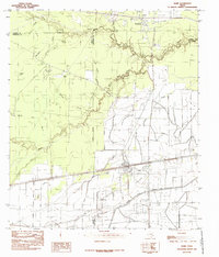
1984 Map of Nome
USGS Topo · Published 1985About this map
The low-lying coastal prairies of Jefferson, Hardin, and Liberty Counties are captured here in the mid-1970s, defined by a complex network of drainage and irrigation. The settlement of Nome serves as a local hub along the Southern Pacific railroad, while the smaller community of Grayburg sits to the north. The landscape is a mosaic of open grasslands including Swift Prairie, Whitehead Prairie, and Big Prairie, segmented by a serpentine drainage system. Natural waterways like Pine Island Bayou and Willow Creek are supplemented by man-made infrastructure such as the Lower Neches Valley Authority Canal, reflecting the region's agricultural reliance on water management. Smaller details for local historians include a secluded Air Strip, several small Cem sites, and curiously named features like Uncle Charlie Slough and Negro Gully.
Find a feature on this map
26 named features on this map. Tap any name to fly to it.
Don’t see what you’re looking for? This feature index may not catch every label — zoom into the map to look around manually.
Map Details
Editions of this 1984 Nome Map
This is the sole edition of this map. No revisions or reprints were ever made.
Other maps of this area

1943 · Whites Bayou
USGS Topo · 1:24,000

1943 · Liberty
USGS Topo · 1:125,000

1945 · Nolte
USGS Topo · 1:31,680

1950 · Houston
USGS Topo · 1:250,000

1954 · Beaumont
USGS Topo · 1:250,000

1955 · Daisetta
USGS Topo · 1:62,500

1955 · Sour Lake
USGS Topo · 1:62,500

1956 · Houston
USGS Topo · 1:250,000

1957 · Beaumont
USGS Topo · 1:250,000
1961 · Whites Bayou
USGS Topo · 1:24,000