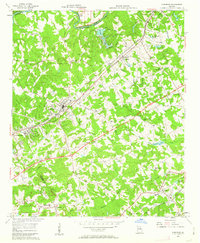
1956 Map of Norcross
USGS Topo · Published 1963About this map
Southern Railway and the Seaboard Air Line define the early industrial corridor of this landscape northeast of Atlanta. The Chattahoochee River forms the natural boundary to the northwest, crossed by the Medlock Bridge and providing the site for several private landings. This mid-century survey documents the transition of Gwinnett and De Kalb counties as the Northeast Expressway began to reshape local transit, intersecting older routes like Goshen Springs Rd and Indian Trail Road. Significant local gathering places include Mt Carmel Ch, Shiloh Ch, and Pleasant Hill Ch, while the residential patterns of Norcross, Duluth, and Lilburn reflect established rail-side growth. Water features like Berkeley Lake and Freeman Lake dot the terrain, alongside smaller landmarks such as the Landing Strip and Lucky Shoals.
Find a feature on this map
59 named features on this map. Tap any name to fly to it.
Don’t see what you’re looking for? This feature index may not catch every label — zoom into the map to look around manually.
Map Details
Editions of this 1956 Norcross Map
4 editions found
Other maps of this area

1888 · Atlanta
USGS Topo · 1:125,000

1890 · Suwanee
USGS Topo · 1:125,000

1890 · Atlanta
USGS Topo · 1:125,000

1892 · Atlanta
USGS Topo · 1:125,000

1894 · Suwanee
USGS Topo · 1:125,000

1895 · Atlanta
USGS Topo · 1:125,000

1953 · Atlanta
USGS Topo · 1:250,000

1954 · Chamblee
USGS Topo · 1:24,000

1954 · Decatur
USGS Topo · 1:24,000

1955 · Rome
USGS Topo · 1:250,000