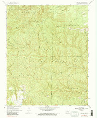
1966 Map of Norfork SE
USGS Topo · Published 1984About this map
Push Mountain and Tassel Spring Mountain dominate this mid-century view of the Arkansas Ozarks along the Baxter and Stone county line. The landscape is defined by the deep incisions of the Ozark National Forest, where a network of remote waterways like Birmingham Hollow, Cripple Turkey Creek, and Barkshed Creek carve through the limestone terrain. Human presence is sparse and largely concentrated along the higher elevations and ridgelines. Local history is preserved in small landmarks such as Acklin Cem near Sneeds and a prominent Lookout Tower on the western heights. The map records a transition in accessibility, showing a mix of established routes like Beaver Road alongside numerous miles of Jeep Trails that penetrate the dense forest. Recreational and industrial markers, including the Barkshed Picnic Area and a Gravel Pit, highlight the varied use of this rugged timberland.
Find a feature on this map
43 named features on this map. Tap any name to fly to it.
Don’t see what you’re looking for? This feature index may not catch every label — zoom into the map to look around manually.
Map Details
Editions of this 1966 Norfork SE Map
3 editions found
Other maps of this area

1890 · Mountain Home
USGS Topo · 1:125,000

1891 · Mountain Home
USGS Topo · 1:125,000

1892 · Mountain View
USGS Topo · 1:125,000

1894 · Mountain View
USGS Topo · 1:125,000

1894 · Mountain Home
USGS Topo · 1:125,000

1945 · Harrison
USGS Topo · 1:250,000

1949 · Harrison
USGS Topo · 1:250,000

1954 · Harrison
USGS Topo · 1:250,000

1956 · Russellville
USGS Topo · 1:250,000

1958 · Harrison
USGS Topo · 1:250,000