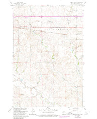
1980 Map of North Almont
USGS Topo · Published 1980About this map
North Almont and the surrounding prairie of Morton County are captured here during a period of infrastructure transition in the late twentieth century. The landscape is defined by the drainage of Hailstone Creek and Muskrat Creek as they flow through the Schollaert Hills. A clear record of industrial history is visible where the Northern Pacific railroad line runs parallel to an Old Railroad Grade, showing the shifting path of rail transit through the region. Local genealogy is well-supported by the inclusion of the Peace Ch and rural burial sites such as BM Cem and English Cem. The southern portion of the map is dominated by the Muddy Valley Creek and the prominent Curlew Buttes, while modern transportation is represented by Interstate 94 and its associated Rest Area.
Find a feature on this map
26 named features on this map. Tap any name to fly to it.
Don’t see what you’re looking for? This feature index may not catch every label — zoom into the map to look around manually.
Map Details
Editions of this 1980 North Almont Map
This is the sole edition of this map. No revisions or reprints were ever made.
Other maps of this area

1954 · Bismarck
USGS Topo · 1:250,000

1958 · Bismarck
USGS Topo · 1:250,000

1960 · North Almont
USGS Topo · 1:24,000

1960 · Dengate
USGS Topo · 1:24,000

1960 · New Salem
USGS Topo · 1:24,000

1970 · Bluegrass
USGS Topo · 1:24,000

1970 · New Salem NW
USGS Topo · 1:24,000

1970 · Hailstone Butte
USGS Topo · 1:24,000

1980 · Crown Butte Creek NW
USGS Topo · 1:24,000

1980 · Almont East
USGS Topo · 1:24,000