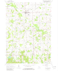
1963 Map of North Branch
USGS Topo · Published 1982About this map
North Branch serves as the primary hub of this Lapeer County landscape, situated at the intersection of local routes in a region defined by agricultural plots and an intricate drainage system. The settlement of Five Lakes lies further south, providing a second point of human concentration near the Five Lakes Sch and the waters of Lees Lake. The terrain is marked by a high density of small water bodies and man-made ditches, including the North Branch Flint River, Elm Creek, and Bottom Drain, which support the surrounding farmland.
Find a feature on this map
60 named features on this map. Tap any name to fly to it.
Don’t see what you’re looking for? This feature index may not catch every label — zoom into the map to look around manually.
Map Details
Editions of this 1963 North Branch Map
2 editions found
Other maps of this area

1954 · Flint
USGS Topo · 1:250,000

1958 · Flint
USGS Topo · 1:250,000

1963 · Clifford
USGS Topo · 1:24,000

1963 · Attica
USGS Topo · 1:24,000

1963 · Mayville
USGS Topo · 1:24,000

1963 · Marlette
USGS Topo · 1:24,000

1963 · North Branch
USGS Topo · 1:24,000

1963 · Burnside
USGS Topo · 1:24,000
1963 · Imlay City
USGS Topo · 1:24,000
1963 · Barnes Lake
USGS Topo · 1:24,000