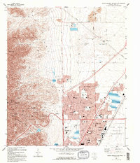
1995 Map of North Franklin Mountain
USGS Topo · Published 1995About this map
Franklin Mountains State Park dominates the western half of this landscape, rising to the prominent heights of North Franklin Mountain and the distinctive Anthonys Nose. The steep, arid terrain is cut by numerous canyons, including Hitt Canyon and Fusselman Canyon, which descend toward the suburban expansion of El Paso to the east. This 1995 revision reveals a dense network of schools and civic infrastructure at the mountain's base, from Irvin High School to the El Paso Community College (Transmountain Campus).
Find a feature on this map
76 named features on this map. Tap any name to fly to it.
Don’t see what you’re looking for? This feature index may not catch every label — zoom into the map to look around manually.
Map Details
Editions of this 1995 North Franklin Mountain Map
This is the sole edition of this map. No revisions or reprints were ever made.
Other maps of this area

1891 · Las Cruces
USGS Topo · 1:125,000

1893 · Las Cruces
USGS Topo · 1:125,000

1896 · El Paso
USGS Topo · 1:125,000

1908 · El Paso
USGS Topo · 1:125,000

1917 · Canutillo
USGS Topo · 1:62,500

1919 · Canutillo
USGS Topo · 1:62,500

1940 · Newman
USGS Topo · 1:62,500

1941 · El Paso
USGS Topo · 1:31,680

1942 · Fort Bliss
USGS Topo · 1:62,500

1943 · La Mesa
USGS Topo · 1:62,500