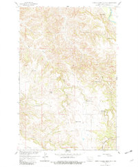
1958 Map of North Killdeer Mountain
USGS Topo · Published 1982About this map
The North Killdeer Mountain massif dominates this landscape in the Missouri River Basin, revealing a late-1950s ranching economy defined by isolated homesteads and complex drainage networks. Cattle operations are spread across the broken terrain, with the Hanson Ranch, Peterson Ranch, and Blee Ranch situated among the draws and coulees. The map illustrates how local life was tethered to the intermittent water sources of the badlands, following the course of the L Missouri R and its tributaries like Bear Creek and Chase Creek.
Find a feature on this map
20 named features on this map. Tap any name to fly to it.
Don’t see what you’re looking for? This feature index may not catch every label — zoom into the map to look around manually.
Map Details
Editions of this 1958 North Killdeer Mountain Map
2 editions found
Other maps of this area

1953 · Watford City
USGS Topo · 1:250,000

1957 · Watford City
USGS Topo · 1:250,000

1958 · Lone Butte SE
USGS Topo · 1:24,000

1958 · North Killdeer Mountain
USGS Topo · 1:24,000

1959 · Croff
USGS Topo · 1:24,000

1959 · Lone Butte NE
USGS Topo · 1:24,000

1967 · Watford City
USGS Topo · 1:250,000

1970 · Lost Bridge
USGS Topo · 1:24,000

1970 · Figure 4 Ranch
USGS Topo · 1:24,000

1974 · Killdeer
USGS Topo · 1:100,000