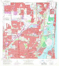
1962 Map of North Miami
USGS Topo · Published 1971About this map
Barry College and the surrounding neighborhoods of North Miami and North Miami Beach characterize this coastal landscape as it transition from suburban expansion to the waters of Biscayne Bay. The map documents a complex network of man-made waterways, including the Intracoastal Waterway and various finger canals that created residential developments like the Keystone Islands and Golden Isles. The intersection of Floridas Turnpike and the Palmetto Expressway highlights the era's focus on high-speed transit, while older natural features like the Oleta River and Snake Creek persist alongside the expanding grid.
Find a feature on this map
106 named features on this map. Tap any name to fly to it.
Don’t see what you’re looking for? This feature index may not catch every label — zoom into the map to look around manually.
Map Details
Editions of this 1962 North Miami Map
3 editions found
Other maps of this area

1947 · North Miami
USGS Topo · 1:24,000

1949 · Opalocka
USGS Topo · 1:24,000

1949 · Port Everglades
USGS Topo · 1:24,000

1949 · Fort Lauderdale South
USGS Topo · 1:24,000

1950 · Hialeah
USGS Topo · 1:24,000

1950 · Miami
USGS Topo · 1:24,000

1950 · North Miami
USGS Topo · 1:24,000

1956 · Miami
USGS Topo · 1:250,000

1956 · West Palm Beach
USGS Topo · 1:250,000

1957 · West Palm Beach
USGS Topo · 1:250,000