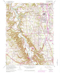
1963 Map of Northfield
USGS Topo · Published 1979About this map
The Cuyahoga River carves a deep, winding valley through this landscape, marking the boundary between Cuyahoga and Summit counties. By the late 1970s, this region shows a complex mix of institutional land use and suburban expansion. Significant medical and state facilities like Hawthornden State Hospital and Sagamore Hills Hospital occupy large tracts near the river bluffs, while the eastern plateau is defined by the growing residential footprints of Northfield and Macedonia.
Find a feature on this map
61 named features on this map. Tap any name to fly to it.
Don’t see what you’re looking for? This feature index may not catch every label — zoom into the map to look around manually.
Map Details
Editions of this 1963 Northfield Map
4 editions found
Other maps of this area

1903 · Cleveland
USGS Topo · 1:62,500

1903 · Akron
USGS Topo · 1:62,500

1905 · Akron
USGS Topo · 1:62,500

1906 · Kent
USGS Topo · 1:62,500

1906 · Chagrin Falls
USGS Topo · 1:62,500

1908 · Chagrin Falls
USGS Topo · 1:62,500

1950 · Cleveland
USGS Topo · 1:250,000

1953 · Chagrin Falls
USGS Topo · 1:24,000

1953 · Shaker Heights
USGS Topo · 1:24,000

1953 · Broadview Heights
USGS Topo · 1:24,000