
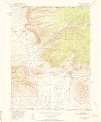
1952 Map of Northgate
USGS Topo · Published 1952About this map
Mining operations and mountain ranching define this high-altitude landscape along the Colorado and Wyoming border in the early 1950s. The North Platte River winds through the western valley, flanked by the steep slopes of Independence Mountain and Watson Mtn. The settlement of Northgate serves as a local hub near the Union Pacific rail line, supporting an active mineral extraction economy. Evidence of this industrial activity is scattered across the eastern peaks, including the Camp Creek Mine, Fluorspar Mine, and Gero Tunnel. Irrigation systems like the Durgin Ditch indicate the adaptation of the land for cattle and agriculture, while the Quaintance Ranch highlights early land use in the northern reaches of the Routt National Forest.
Find a feature on this map
28 named features on this map. Tap any name to fly to it.
Don’t see what you’re looking for? This feature index may not catch every label — zoom into the map to look around manually.
Map Details
Editions of this 1952 Northgate Map
2 editions found
Other maps of this area

1906 · Medicine Bow
USGS Topo · 1:125,000

1908 · Medicine Bow
USGS Topo · 1:125,000

1950 · Northgate
USGS Topo · 1:24,000

1950 · Kings Canyon
USGS Topo · 1:24,000

1952 · Kings Canyon
USGS Topo · 1:24,000

1954 · Rawlins
USGS Topo · 1:250,000

1954 · Craig
USGS Topo · 1:250,000

1955 · Independence Mountain
USGS Topo · 1:24,000

1955 · Lake John
USGS Topo · 1:24,000

1955 · Eagle Hill
USGS Topo · 1:24,000