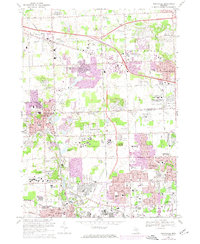
1969 Map of Northville
USGS Topo · Published 1974About this map
The boundary between Oakland Co and Wayne Co defines the geography of this mid-century map, where the sprawling suburban expansion of Southeast Michigan is visible in purple revision tint. The landscape is characterized by its institutional complexes and expansive cemeteries, including the massive Northville State Hospital and the Plymouth State Home and Training Sch. The rail lines of the Chesapeake and Ohio connect the centers of Northville and Plymouth, while the northern portion of the quadrangle shows the growth of Novi and Farmington. Numerous golf courses, such as the Meadowbrook Country Club and Whispering Willows Golf Course, appear alongside residential developments like Grand View Acres. Educational and religious sites are frequent, from St John Seminary to Schoolcraft College, documenting a period of significant civic and social infrastructure building.
Find a feature on this map
92 named features on this map. Tap any name to fly to it.
Don’t see what you’re looking for? This feature index may not catch every label — zoom into the map to look around manually.
Map Details
Editions of this 1969 Northville Map
4 editions found
Other maps of this area

1902 · South Lyon
USGS Topo · 1:62,500

1904 · Ann Arbor
USGS Topo · 1:125,000

1905 · Wayne
USGS Topo · 1:62,500

1906 · South Lyon
USGS Topo · 1:62,500

1907 · Pontiac
USGS Topo · 1:62,500

1908 · Ann Arbor
USGS Topo · 1:125,000

1909 · Milford
USGS Topo · 1:62,500

1912 · Wayne
USGS Topo · 1:62,500

1936 · Inkster
USGS Topo · 1:31,680

1936 · Wayne
USGS Topo · 1:31,680