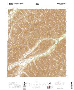
2017 Map of Norton Bay C-1 SE
USGS Topo · Published 2017About this map
Mt Itliaruk stands as a prominent topographical landmark in this interior Alaskan landscape, which is defined by the headwaters and drainage systems of the Nulato River and Kalasik Cr. This 2017 study reveals an unpopulated wilderness where the natural hydrology dictates the geography, undisturbed by modern road networks or permanent settlements. The map details the complex drainage patterns of the Kalasik Cr as it carves through the undulating terrain south of the Nulato River. The absence of man-made infrastructure highlights the area's isolation within the Yukon-Koyukuk region, making this a clear record of the territory's natural state and surveying boundaries like t10s r2w and t11s r3w.
Find a feature on this map
7 named features on this map. Tap any name to fly to it.
Don’t see what you’re looking for? This feature index may not catch every label — zoom into the map to look around manually.
Map Details
Editions of this 2017 Norton Bay C-1 SE Map
This is the sole edition of this map. No revisions or reprints were ever made.
Other maps of this area

1945 · Nulato
USGS Topo · 1:250,000

1948 · Norton Bay
USGS Topo · 1:250,000

1951 · Nulato
USGS Topo · 1:250,000

1951 · Norton Bay
USGS Topo · 1:250,000

1952 · Nulato B-6
USGS Topo · 1:63,360

1952 · Norton Bay B-1
USGS Topo · 1:63,360

1952 · Nulato C-6
USGS Topo · 1:63,360

1952 · Nulato
USGS Topo · 1:250,000
1952 · Norton Bay C-1
USGS Topo · 1:63,360
1953 · Nulato C-6
USGS Topo · 1:63,360