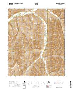
2017 Map of Norton Bay D-2 NE
USGS Topo · Published 2017About this map
The Ungalik River cuts through the northwest corner of this interior landscape, marking one of the few named topographical landmarks in a region defined by high elevation contours and complex drainage patterns. This 2017 study illustrates the intersection of the Nome Census Area and the Yukon-Koyukuk Census Area, an administrative boundary that traverses the heart of the terrain. The map is primarily characterized by the public land survey system divisions of t6s r5w, t6s r4w, t7s r5w, and t7s r4w, providing a precise grid for modern land management in this remote part of Alaska. The absence of named settlements or road infrastructure emphasizes the wilderness character of the area, making the hydrographic detail of the river and its unnamed tributaries the primary features of interest for geographical study.
Find a feature on this map
6 named features on this map. Tap any name to fly to it.
Don’t see what you’re looking for? This feature index may not catch every label — zoom into the map to look around manually.
Map Details
Editions of this 2017 Norton Bay D-2 NE Map
This is the sole edition of this map. No revisions or reprints were ever made.
Other maps of this area

1948 · Norton Bay
USGS Topo · 1:250,000

1951 · Candle
USGS Topo · 1:250,000

1951 · Norton Bay
USGS Topo · 1:250,000

1954 · Candle A-2
USGS Topo · 1:63,360

1954 · Candle A-1
USGS Topo · 1:63,360

1954 · Norton Bay D-2
USGS Topo · 1:63,360
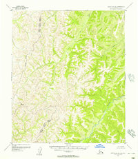
1955 · Norton Bay D-1
USGS Topo · 1:63,360

1955 · Candle
USGS Topo · 1:250,000

1955 · Norton Bay
USGS Topo · 1:250,000

1955 · Candle A-2
USGS Topo · 1:63,360