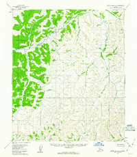
1954 Map of Norton Bay D-2
USGS Topo · Published 1960About this map
Ungalik River defines the central drainage of this interior Alaskan landscape, which was documented by the U.S. Geological Survey using aerial photography from the early 1950s. The terrain is dominated by a complex network of unnamed ridges and valleys, with sparse vegetation concentrated along the primary watercourses. To the southeast, Egavik Creek flows toward the coast, marking one of the few named landmarks in this expansive territory. This 1954 survey captures the region as it existed before significant modern mapping or infrastructure development reached this portion of the Norton Bay quadrangle, representing a period when the land was primarily understood through topographic contouring rather than established settlements or roads.
Find a feature on this map
2 named features on this map. Tap any name to fly to it.
Don’t see what you’re looking for? This feature index may not catch every label — zoom into the map to look around manually.
Map Details
Editions of this 1954 Norton Bay D-2 Map
2 editions found
Other maps of this area

1948 · Norton Bay
USGS Topo · 1:250,000

1950 · Norton Bay C-3
USGS Topo · 1:63,360

1950 · Norton Bay D-3
USGS Topo · 1:63,360

1951 · Candle
USGS Topo · 1:250,000

1951 · Norton Bay
USGS Topo · 1:250,000
1952 · Norton Bay C-1
USGS Topo · 1:63,360

1953 · Norton Bay C-2
USGS Topo · 1:63,360

1954 · Candle A-2
USGS Topo · 1:63,360

1954 · Candle A-1
USGS Topo · 1:63,360

1954 · Norton Bay D-2
USGS Topo · 1:63,360