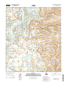
2014 Map of Norton Bay D-4 NW
USGS Topo · Published 2014About this map
Koyuk River meanders across the northwestern portion of this 2014 survey, carving a broad, watery path through the low-lying terrain. The map documents a sparsely populated landscape near the Norton Bay coast, where transportation is defined by isolated terrestrial routes like the Koyuk Road To E Fork and the Koyuk Inglutalik River Road. These trails suggest the historical and contemporary importance of overland passage between local waterways in this subarctic environment. To the southeast, the Akulik River provides a secondary drainage system, illustrating the intricate network of wetlands and small ponds that dominate the Seward Peninsula's topography. The lack of named settlements emphasizes the area's character as a wilderness corridor for resource access and travel between regional hubs.
Find a feature on this map
10 named features on this map. Tap any name to fly to it.
Don’t see what you’re looking for? This feature index may not catch every label — zoom into the map to look around manually.
Map Details
Editions of this 2014 Norton Bay D-4 NW Map
This is the sole edition of this map. No revisions or reprints were ever made.
Other maps of this area

1948 · Norton Bay
USGS Topo · 1:250,000

1950 · Norton Bay D-5
USGS Topo · 1:63,360

1950 · Candle A-5
USGS Topo · 1:63,360

1950 · Norton Bay D-4
USGS Topo · 1:63,360

1951 · Candle
USGS Topo · 1:250,000

1951 · Norton Bay
USGS Topo · 1:250,000

1955 · Candle
USGS Topo · 1:250,000

1955 · Norton Bay
USGS Topo · 1:250,000
1955 · Candle A-4
USGS Topo · 1:63,360

1964 · Candle
USGS Topo · 1:250,000