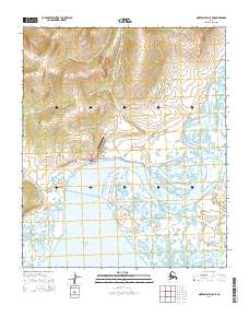
2014 Map of Norton Bay D-5 NE
USGS Topo · Published 2014About this map
Koyuk sits at the head of the Koyuk Inlet on the southern coast of the Seward Peninsula, where the Koyuk River meets the Bering Sea. This 2014 survey captures a northern coastal settlement defined by its relationship to the water and a network of specialized access roads. The local geography is shaped by the tidal influences of the inlet and the winding courses of the Miniatulik River and Mukluktulik River. A look at the infrastructure reveals the practical necessities of life in this part of Alaska, featuring the Koyuk Airport and local thoroughfares like Barge Access Road and King Creek Road. Further inland, the map traces the Koyuk Hotsprings Road and Devil's Mountain Road, suggesting the routes taken for resource access and travel into the interior toward the Road to E Fork.
Find a feature on this map
24 named features on this map. Tap any name to fly to it.
Don’t see what you’re looking for? This feature index may not catch every label — zoom into the map to look around manually.
Map Details
Editions of this 2014 Norton Bay D-5 NE Map
This is the sole edition of this map. No revisions or reprints were ever made.
Other maps of this area

1948 · Norton Bay
USGS Topo · 1:250,000

1950 · Norton Bay D-5
USGS Topo · 1:63,360

1950 · Candle A-5
USGS Topo · 1:63,360

1950 · Norton Bay D-4
USGS Topo · 1:63,360

1951 · Candle
USGS Topo · 1:250,000

1951 · Norton Bay
USGS Topo · 1:250,000

1955 · Candle
USGS Topo · 1:250,000

1955 · Norton Bay
USGS Topo · 1:250,000
1955 · Candle A-4
USGS Topo · 1:63,360

1964 · Candle
USGS Topo · 1:250,000