1951 Map of Norton Bay
USGS Topo · Published 1951About this map
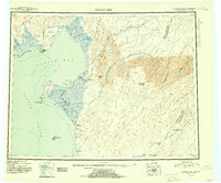
Koyuk and Egavik anchor the coastal landscape of the Seward Peninsula and Norton Sound on this mid-century reconnaissance. The mapping highlights a logistics network reliant on isolated waypoints, including Shaktolik Roadhouse, Isaacs Roadhouse, and several named dwellings like Old Woman Cabin. These sites served as essential stops along trails and rivers before the expansion of modern infrastructure.
Find a feature on this map
52 named features on this map. Tap any name to fly to it.
Don’t see what you’re looking for? This feature index may not catch every label — zoom into the map to look around manually.
Map Details
Editions of this 1951 Norton Bay Map
2 editions found
Historical Maps of Koyuk Through Time
591 maps found

1907 Casadepaga
Nome Borough, AK

1907 Solomon
Nome Borough, AK

1948 Norton Bay
Nome Borough, AK

1948 St Lawrence
Nome Borough, AK

1949 St Lawrence
Nome Borough, AK

1950 Bendeleben A-1
Nome Borough, AK

1950 Bendeleben A-2
Nome Borough, AK

1950 Bendeleben A-3
Nome Borough, AK

1950 Bendeleben A-4
Nome Borough, AK

1950 Bendeleben A-5
Nome Borough, AK

1950 Bendeleben A-6
Nome Borough, AK

1950 Bendeleben B-1
Nome Borough, AK

1950 Bendeleben B-2
Nome Borough, AK

1950 Bendeleben B-3
Nome Borough, AK

1950 Bendeleben B-4
Nome Borough, AK

1950 Bendeleben B-5
Nome Borough, AK

1950 Bendeleben B-6
Nome Borough, AK

1950 Bendeleben C-5
Nome Borough, AK

1950 Bendeleben C-6
Nome Borough, AK

1950 Bendeleben D-5
Nome Borough, AK

1950 Bendeleben D-6
Nome Borough, AK

1950 Bendeleben
Nome Borough, AK

1950 Candle A-5
Nome Borough, AK

1950 Candle A-6
Nome Borough, AK

1950 Candle B-5
Nome Borough, AK

1950 Candle B-6
Nome Borough, AK

1950 Kotzebue A-6
Nome Borough, AK

1950 Kotzebue B-6
Nome Borough, AK

1950 Kotzebue C-6
Nome Borough, AK

1950 Nome B-1
Nome Borough, AK

1950 Nome C-1
Nome Borough, AK

1950 Nome C-2
Nome Borough, AK

1950 Nome C-3
Nome Borough, AK

1950 Nome D-1
Nome Borough, AK

1950 Nome D-2
Nome Borough, AK

1950 Nome D-3
Nome Borough, AK

1950 Nome D-4
Nome Borough, AK

1950 Norton Bay A-3
Nome Borough, AK

1950 Norton Bay A-4
Nome Borough, AK

1950 Norton Bay B-3
Nome Borough, AK

1950 Norton Bay B-4
Nome Borough, AK

1950 Norton Bay B-5
Nome Borough, AK

1950 Norton Bay C-3
Nome Borough, AK

1950 Norton Bay C-4
Nome Borough, AK

1950 Norton Bay C-5
Nome Borough, AK

1950 Norton Bay C-6
Nome Borough, AK

1950 Norton Bay D-3
Nome Borough, AK

1950 Norton Bay D-4
Nome Borough, AK

1950 Norton Bay D-5
Nome Borough, AK

1950 Norton Bay D-6
Nome Borough, AK

1950 Shishmaref A-1
Nome Borough, AK

1950 Shishmaref A-2
Nome Borough, AK

1950 Shishmaref A-3
Nome Borough, AK

1950 Shishmaref A-4
Nome Borough, AK

1950 Shishmaref B-1
Nome Borough, AK

1950 Shishmaref B-2
Nome Borough, AK

1950 Shishmaref B-3
Nome Borough, AK

1950 Solomon B-2
Nome Borough, AK

1950 Solomon B-3
Nome Borough, AK

1950 Solomon B-6
Nome Borough, AK

1950 Solomon C-1
Nome Borough, AK

1950 Solomon C-2
Nome Borough, AK

1950 Solomon C-3
Nome Borough, AK

1950 Solomon C-4
Nome Borough, AK

1950 Solomon C-5
Nome Borough, AK

1950 Solomon C-6
Nome Borough, AK

1950 Solomon D-1
Nome Borough, AK

1950 Solomon D-2
Nome Borough, AK

1950 Solomon D-3
Nome Borough, AK

1950 Solomon D-4
Nome Borough, AK

1950 Solomon D-5
Nome Borough, AK

1950 Solomon D-6
Nome Borough, AK

1950 Solomon
Nome Borough, AK

1950 Teller A-1
Nome Borough, AK

1950 Teller A-2
Nome Borough, AK

1950 Teller A-3
Nome Borough, AK

1950 Teller A-4
Nome Borough, AK

1950 Teller B-1
Nome Borough, AK

1950 Teller B-2
Nome Borough, AK

1950 Teller B-3
Nome Borough, AK

1950 Teller B-4
Nome Borough, AK

1950 Teller B-5
Nome Borough, AK

1950 Teller B-6
Nome Borough, AK

1950 Teller C-1
Nome Borough, AK

1950 Teller C-2
Nome Borough, AK

1950 Teller C-3
Nome Borough, AK

1950 Teller C-4
Nome Borough, AK

1950 Teller C-5
Nome Borough, AK

1950 Teller C-6
Nome Borough, AK

1950 Teller C-7
Nome Borough, AK

1950 Teller D-1
Nome Borough, AK

1950 Teller D-2
Nome Borough, AK

1950 Teller D-3
Nome Borough, AK

1950 Teller D-4
Nome Borough, AK

1950 Teller D-5
Nome Borough, AK

1950 Teller D-6
Nome Borough, AK

1950 Unalakleet D-3
Nome Borough, AK

1950 Unalakleet D-4
Nome Borough, AK

1951 Bendeleben
Nome Borough, AK

1951 Norton Bay
Nome Borough, AK

1951 Solomon
Nome Borough, AK

1952 Saint Michael B-1
Nome Borough, AK

1952 Saint Michael B-2
Nome Borough, AK

1952 Saint Michael C-1
Nome Borough, AK

1952 Saint Michael C-2
Nome Borough, AK

1952 Unalakleet A-5
Nome Borough, AK

1952 Unalakleet A-6
Nome Borough, AK

1952 Unalakleet B-4
Nome Borough, AK

1952 Unalakleet B-5
Nome Borough, AK

1952 Unalakleet B-6
Nome Borough, AK

1952 Unalakleet C-4
Nome Borough, AK

1952 Unalakleet C-5
Nome Borough, AK

1952 Unalakleet D-2
Nome Borough, AK

1954 Candle A-2
Nome Borough, AK

1954 Candle B-2
Nome Borough, AK

1954 Norton Bay D-2
Nome Borough, AK

1955 Candle A-2
Nome Borough, AK

1955 Candle A-4
Nome Borough, AK

1955 Candle B-3
Nome Borough, AK

1955 Candle B-4
Nome Borough, AK

1955 Norton Bay
Nome Borough, AK

1964 Bendeleben
Nome Borough, AK

1964 St Lawrence
Nome Borough, AK

1970 Bendeleben A-4
Nome Borough, AK

1972 Nome D-1
Nome Borough, AK

1975 Nome C-3
Nome Borough, AK

2014 Bendeleben B-6 NE
Nome Borough, AK

2014 Bendeleben B-6 NW
Nome Borough, AK

2014 Bendeleben C-5 NW
Nome Borough, AK

2014 Bendeleben C-5 SW
Nome Borough, AK

2014 Bendeleben C-6 NE
Nome Borough, AK

2014 Bendeleben C-6 NW
Nome Borough, AK

2014 Bendeleben C-6 SE
Nome Borough, AK

2014 Bendeleben C-6 SW
Nome Borough, AK

2014 Bendeleben D-5 NW
Nome Borough, AK

2014 Bendeleben D-5 SW
Nome Borough, AK

2014 Bendeleben D-6 NE
Nome Borough, AK

2014 Bendeleben D-6 NW
Nome Borough, AK

2014 Bendeleben D-6 SE
Nome Borough, AK

2014 Bendeleben D-6 SW
Nome Borough, AK

2014 Candle A-3 NE
Nome Borough, AK

2014 Candle A-3 NW
Nome Borough, AK

2014 Candle A-3 SE
Nome Borough, AK

2014 Candle A-3 SW
Nome Borough, AK

2014 Candle A-4 NE
Nome Borough, AK

2014 Candle A-4 NW
Nome Borough, AK

2014 Candle A-4 SE
Nome Borough, AK

2014 Candle A-4 SW
Nome Borough, AK

2014 Candle A-5 NE
Nome Borough, AK

2014 Candle A-5 NW
Nome Borough, AK

2014 Candle A-5 SE
Nome Borough, AK

2014 Candle A-5 SW
Nome Borough, AK

2014 Candle B-2 NW
Nome Borough, AK

2014 Candle B-3 NW
Nome Borough, AK

2014 Candle B-3 SW
Nome Borough, AK

2014 Candle B-4 NE
Nome Borough, AK

2014 Candle B-4 NW
Nome Borough, AK

2014 Candle B-4 SE
Nome Borough, AK

2014 Candle B-4 SW
Nome Borough, AK

2014 Candle B-5 NE
Nome Borough, AK

2014 Candle B-5 NW
Nome Borough, AK

2014 Candle B-5 SE
Nome Borough, AK

2014 Candle B-5 SW
Nome Borough, AK

2014 Candle B-6 NE
Nome Borough, AK

2014 Kotzebue A-5 NW
Nome Borough, AK

2014 Kotzebue A-5 SW
Nome Borough, AK

2014 Kotzebue A-6 NE
Nome Borough, AK

2014 Kotzebue A-6 NW
Nome Borough, AK

2014 Kotzebue A-6 SE
Nome Borough, AK

2014 Kotzebue A-6 SW
Nome Borough, AK

2014 Kotzebue B-5 NW
Nome Borough, AK

2014 Kotzebue B-5 SW
Nome Borough, AK

2014 Kotzebue B-6 NE
Nome Borough, AK

2014 Kotzebue B-6 NW
Nome Borough, AK

2014 Kotzebue B-6 SE
Nome Borough, AK

2014 Kotzebue B-6 SW
Nome Borough, AK

2014 Kotzebue C-6 SE
Nome Borough, AK

2014 Kotzebue C-6 SW
Nome Borough, AK

2014 Norton Bay A-4 NW
Nome Borough, AK

2014 Norton Bay A-4 SW
Nome Borough, AK

2014 Norton Bay B-4 NW
Nome Borough, AK

2014 Norton Bay B-4 SW
Nome Borough, AK

2014 Norton Bay B-5 NE
Nome Borough, AK

2014 Norton Bay B-5 NW
Nome Borough, AK

2014 Norton Bay B-5 OE S NW
Nome Borough, AK

2014 Norton Bay B-5 OE S SW
Nome Borough, AK

2014 Norton Bay B-5 OE W NE
Nome Borough, AK

2014 Norton Bay B-5 SE
Nome Borough, AK

2014 Norton Bay C-4 NE
Nome Borough, AK

2014 Norton Bay C-4 NW
Nome Borough, AK

2014 Norton Bay C-4 SW
Nome Borough, AK

2014 Norton Bay C-5 SE
Nome Borough, AK

2014 Norton Bay C-5 SW
Nome Borough, AK

2014 Norton Bay C-6 NE
Nome Borough, AK

2014 Norton Bay C-6 NW
Nome Borough, AK

2014 Norton Bay D-4 NE
Nome Borough, AK

2014 Norton Bay D-4 NW
Nome Borough, AK

2014 Norton Bay D-4 SE
Nome Borough, AK

2014 Norton Bay D-4 SW
Nome Borough, AK

2014 Norton Bay D-5 NE
Nome Borough, AK

2014 Norton Bay D-5 NW
Nome Borough, AK

2014 Norton Bay D-5 SE
Nome Borough, AK

2014 Norton Bay D-5 SW
Nome Borough, AK

2014 Norton Bay D-6 NE
Nome Borough, AK

2014 Norton Bay D-6 NW
Nome Borough, AK

2014 Norton Bay D-6 SE
Nome Borough, AK

2014 Norton Bay D-6 SW
Nome Borough, AK

2014 Shishmaref A-1 NE
Nome Borough, AK

2014 Shishmaref A-1 NW
Nome Borough, AK

2014 Shishmaref A-1 SE
Nome Borough, AK

2014 Shishmaref A-1 SW
Nome Borough, AK

2014 Shishmaref A-2 NE
Nome Borough, AK

2014 Shishmaref A-2 NW
Nome Borough, AK

2014 Shishmaref A-2 SE
Nome Borough, AK

2014 Shishmaref A-2 SW
Nome Borough, AK

2014 Shishmaref A-3 NE
Nome Borough, AK

2014 Shishmaref A-3 NW
Nome Borough, AK

2014 Shishmaref A-3 SE
Nome Borough, AK

2014 Shishmaref A-3 SW
Nome Borough, AK

2014 Shishmaref A-4 NE
Nome Borough, AK

2014 Shishmaref A-4 SE
Nome Borough, AK

2014 Shishmaref A-4 SW
Nome Borough, AK

2014 Shishmaref B-1 NE
Nome Borough, AK

2014 Shishmaref B-1 NW
Nome Borough, AK

2014 Shishmaref B-1 SE
Nome Borough, AK

2014 Shishmaref B-1 SW
Nome Borough, AK

2014 Shishmaref B-2 NE
Nome Borough, AK

2014 Shishmaref B-2 SE
Nome Borough, AK

2014 Shishmaref B-2 SW
Nome Borough, AK

2014 Shishmaref B-3 SE
Nome Borough, AK

2014 Solomon B-2 NE
Nome Borough, AK

2014 Solomon B-2 NW
Nome Borough, AK

2014 Solomon B-2 SE
Nome Borough, AK

2014 Solomon B-2 SW
Nome Borough, AK

2014 Solomon B-3 NE
Nome Borough, AK

2014 Solomon B-3 NW
Nome Borough, AK

2014 Solomon B-6 NE
Nome Borough, AK

2014 Solomon C-1 NE
Nome Borough, AK

2014 Solomon C-1 NW
Nome Borough, AK

2014 Solomon C-1 SE
Nome Borough, AK

2014 Solomon C-1 SW
Nome Borough, AK

2014 Solomon C-2 NE
Nome Borough, AK

2014 Solomon C-2 NW
Nome Borough, AK

2014 Solomon C-2 SE
Nome Borough, AK

2014 Solomon C-2 SW
Nome Borough, AK

2014 Solomon C-3 SE
Nome Borough, AK

2014 Solomon D-1 NE
Nome Borough, AK

2014 Solomon D-1 NW
Nome Borough, AK

2014 Solomon D-1 SE
Nome Borough, AK

2014 Solomon D-1 SW
Nome Borough, AK

2014 Solomon D-2 NE
Nome Borough, AK

2014 Solomon D-2 SE
Nome Borough, AK

2014 Teller B-1 NE
Nome Borough, AK

2014 Teller B-1 NW
Nome Borough, AK

2014 Teller B-1 SE
Nome Borough, AK

2014 Teller B-1 SW
Nome Borough, AK

2014 Teller B-2 NE
Nome Borough, AK

2014 Teller B-2 NW
Nome Borough, AK

2014 Teller B-2 SE
Nome Borough, AK

2014 Teller B-2 SW
Nome Borough, AK

2014 Teller B-3 NE
Nome Borough, AK

2014 Teller B-3 NW
Nome Borough, AK

2014 Teller B-3 SE
Nome Borough, AK

2014 Teller B-3 SW
Nome Borough, AK

2014 Teller B-4 NE
Nome Borough, AK

2014 Teller B-4 NW
Nome Borough, AK

2014 Teller B-4 SE
Nome Borough, AK

2014 Teller B-5 NE
Nome Borough, AK

2014 Teller B-5 NW
Nome Borough, AK

2014 Teller B-6 NE
Nome Borough, AK

2014 Teller C-1 NE
Nome Borough, AK

2014 Teller C-1 NW
Nome Borough, AK

2014 Teller C-1 SE
Nome Borough, AK

2014 Teller C-1 SW
Nome Borough, AK

2014 Teller C-2 NE
Nome Borough, AK

2014 Teller C-2 NW
Nome Borough, AK

2014 Teller C-2 SE
Nome Borough, AK

2014 Teller C-2 SW
Nome Borough, AK

2014 Teller C-3 NE
Nome Borough, AK

2014 Teller C-3 NW
Nome Borough, AK

2014 Teller C-3 SE
Nome Borough, AK

2014 Teller C-3 SW
Nome Borough, AK

2014 Teller C-4 NE
Nome Borough, AK

2014 Teller C-4 NW
Nome Borough, AK

2014 Teller C-4 SE
Nome Borough, AK

2014 Teller C-4 SW
Nome Borough, AK

2014 Teller C-5 NE
Nome Borough, AK

2014 Teller C-5 NW
Nome Borough, AK

2014 Teller C-5 SE
Nome Borough, AK

2014 Teller C-5 SW
Nome Borough, AK

2014 Teller C-6 NE
Nome Borough, AK

2014 Teller C-6 NW
Nome Borough, AK

2014 Teller C-6 SE
Nome Borough, AK

2014 Teller C-6 SW
Nome Borough, AK

2014 Teller D-1 NE
Nome Borough, AK

2014 Teller D-1 NW
Nome Borough, AK

2014 Teller D-1 SE
Nome Borough, AK

2014 Teller D-1 SW
Nome Borough, AK

2014 Teller D-2 NE
Nome Borough, AK

2014 Teller D-2 NW
Nome Borough, AK

2014 Teller D-2 SE
Nome Borough, AK

2014 Teller D-2 SW
Nome Borough, AK

2014 Teller D-3 NE
Nome Borough, AK

2014 Teller D-3 NW
Nome Borough, AK

2014 Teller D-3 SE
Nome Borough, AK

2014 Teller D-3 SW
Nome Borough, AK

2014 Teller D-4 NE
Nome Borough, AK

2014 Teller D-4 NW
Nome Borough, AK

2014 Teller D-4 SE
Nome Borough, AK

2014 Teller D-4 SW
Nome Borough, AK

2014 Teller D-5 NE
Nome Borough, AK

2014 Teller D-5 NW
Nome Borough, AK

2014 Teller D-5 SE
Nome Borough, AK

2014 Teller D-5 SW
Nome Borough, AK

2014 Teller D-6 SE
Nome Borough, AK

2014 Teller D-6 SW
Nome Borough, AK

2015 Candle B-2 NE
Nome Borough, AK

2015 Candle B-2 SE
Nome Borough, AK

2015 Candle B-2 SW
Nome Borough, AK

2015 Candle B-3 SE
Nome Borough, AK

2015 Norton Bay A-3 SE
Nome Borough, AK

2015 Norton Bay A-3 SW
Nome Borough, AK

2015 Norton Bay A-4 SE
Nome Borough, AK

2015 Unalakleet C-3 NE
Nome Borough, AK

2015 Unalakleet C-3 NW
Nome Borough, AK

2015 Unalakleet C-4 NE
Nome Borough, AK

2015 Unalakleet C-4 SE
Nome Borough, AK

2015 Unalakleet D-2 NW
Nome Borough, AK

2015 Unalakleet D-2 SW
Nome Borough, AK

2015 Unalakleet D-3 NE
Nome Borough, AK

2015 Unalakleet D-3 NW
Nome Borough, AK

2015 Unalakleet D-3 SE
Nome Borough, AK

2015 Unalakleet D-3 SW
Nome Borough, AK

2015 Unalakleet D-4 NE
Nome Borough, AK

2015 Unalakleet D-4 SE
Nome Borough, AK

2016 Unalakleet A-4 NW
Nome Borough, AK

2016 Unalakleet A-4 SW
Nome Borough, AK

2016 Unalakleet B-4 NW
Nome Borough, AK

2016 Unalakleet B-4 SW
Nome Borough, AK

2016 Unalakleet C-4 NW
Nome Borough, AK

2016 Unalakleet C-4 SW
Nome Borough, AK

2016 Unalakleet D-4 NW
Nome Borough, AK

2016 Unalakleet D-4 SW
Nome Borough, AK

2017 Bendeleben A-1 NE
Nome Borough, AK

2017 Bendeleben A-1 NW
Nome Borough, AK

2017 Bendeleben A-1 SE
Nome Borough, AK

2017 Bendeleben A-1 SW
Nome Borough, AK

2017 Bendeleben A-2 NE
Nome Borough, AK

2017 Bendeleben A-2 NW
Nome Borough, AK

2017 Bendeleben A-2 SE
Nome Borough, AK

2017 Bendeleben A-2 SW
Nome Borough, AK

2017 Bendeleben A-3 NE
Nome Borough, AK

2017 Bendeleben A-3 NW
Nome Borough, AK

2017 Bendeleben A-3 SE
Nome Borough, AK

2017 Bendeleben A-3 SW
Nome Borough, AK

2017 Bendeleben A-4 NE
Nome Borough, AK

2017 Bendeleben A-4 NW
Nome Borough, AK

2017 Bendeleben A-4 SE
Nome Borough, AK

2017 Bendeleben A-4 SW
Nome Borough, AK

2017 Bendeleben A-5 NE
Nome Borough, AK

2017 Bendeleben A-5 NW
Nome Borough, AK

2017 Bendeleben A-5 SE
Nome Borough, AK

2017 Bendeleben A-5 SW
Nome Borough, AK

2017 Bendeleben A-6 NE
Nome Borough, AK

2017 Bendeleben A-6 NW
Nome Borough, AK

2017 Bendeleben A-6 SE
Nome Borough, AK

2017 Bendeleben A-6 SW
Nome Borough, AK

2017 Bendeleben B-1 NE
Nome Borough, AK

2017 Bendeleben B-1 NW
Nome Borough, AK

2017 Bendeleben B-1 SE
Nome Borough, AK

2017 Bendeleben B-1 SW
Nome Borough, AK

2017 Bendeleben B-2 NE
Nome Borough, AK

2017 Bendeleben B-2 SE
Nome Borough, AK

2017 Bendeleben B-2 SW
Nome Borough, AK

2017 Bendeleben B-3 NE
Nome Borough, AK

2017 Bendeleben B-3 SE
Nome Borough, AK

2017 Bendeleben B-3 SW
Nome Borough, AK

2017 Bendeleben B-4 NW
Nome Borough, AK

2017 Bendeleben B-4 SE
Nome Borough, AK

2017 Bendeleben B-4 SW
Nome Borough, AK

2017 Bendeleben B-5 NE
Nome Borough, AK

2017 Bendeleben B-5 NW
Nome Borough, AK

2017 Bendeleben B-5 SE
Nome Borough, AK

2017 Bendeleben B-5 SW
Nome Borough, AK

2017 Bendeleben B-6 SE
Nome Borough, AK

2017 Bendeleben B-6 SW
Nome Borough, AK

2017 Bendeleben C-4 SW
Nome Borough, AK

2017 Bendeleben C-5 NE
Nome Borough, AK

2017 Bendeleben C-5 SE
Nome Borough, AK

2017 Candle A-2 NE
Nome Borough, AK

2017 Candle A-2 NW
Nome Borough, AK

2017 Candle A-2 SE
Nome Borough, AK

2017 Candle A-2 SW
Nome Borough, AK

2017 Candle A-6 NE
Nome Borough, AK

2017 Candle A-6 NW
Nome Borough, AK

2017 Candle A-6 SE
Nome Borough, AK

2017 Candle A-6 SW
Nome Borough, AK

2017 Candle B-6 NW
Nome Borough, AK

2017 Candle B-6 SE
Nome Borough, AK

2017 Candle B-6 SW
Nome Borough, AK

2017 Nome B-1 NE
Nome Borough, AK

2017 Nome B-1 NW
Nome Borough, AK

2017 Nome C-1 NE
Nome Borough, AK

2017 Nome C-1 NW
Nome Borough, AK

2017 Nome C-1 SE
Nome Borough, AK

2017 Nome C-1 SW
Nome Borough, AK

2017 Nome C-2 NE
Nome Borough, AK

2017 Nome C-2 NW
Nome Borough, AK

2017 Nome C-2 SE
Nome Borough, AK

2017 Nome C-2 SW
Nome Borough, AK

2017 Nome C-3 NE
Nome Borough, AK

2017 Nome C-3 NW
Nome Borough, AK

2017 Nome C-3 OE S NE
Nome Borough, AK

2017 Nome C-3 SE
Nome Borough, AK

2017 Nome C-3 SW
Nome Borough, AK

2017 Nome D-1 NE
Nome Borough, AK

2017 Nome D-1 NW
Nome Borough, AK

2017 Nome D-1 SE
Nome Borough, AK

2017 Nome D-1 SW
Nome Borough, AK

2017 Nome D-2 NE
Nome Borough, AK

2017 Nome D-2 NW
Nome Borough, AK

2017 Nome D-2 SE
Nome Borough, AK

2017 Nome D-2 SW
Nome Borough, AK

2017 Nome D-3 NE
Nome Borough, AK

2017 Nome D-3 NW
Nome Borough, AK

2017 Nome D-3 SE
Nome Borough, AK

2017 Nome D-3 SW
Nome Borough, AK

2017 Nome D-4 NE
Nome Borough, AK

2017 Norton Bay A-2 SW
Nome Borough, AK

2017 Norton Bay A-3 NE
Nome Borough, AK

2017 Norton Bay A-3 NW
Nome Borough, AK

2017 Norton Bay A-4 NE
Nome Borough, AK

2017 Norton Bay B-3 NE
Nome Borough, AK

2017 Norton Bay B-3 NW
Nome Borough, AK

2017 Norton Bay B-3 SE
Nome Borough, AK

2017 Norton Bay B-3 SW
Nome Borough, AK

2017 Norton Bay B-4 NE
Nome Borough, AK

2017 Norton Bay B-4 SE
Nome Borough, AK

2017 Norton Bay C-3 NE
Nome Borough, AK

2017 Norton Bay C-3 NW
Nome Borough, AK

2017 Norton Bay C-3 SE
Nome Borough, AK

2017 Norton Bay C-3 SW
Nome Borough, AK

2017 Norton Bay C-4 SE
Nome Borough, AK

2017 Norton Bay D-2 NW
Nome Borough, AK

2017 Norton Bay D-2 SW
Nome Borough, AK

2017 Norton Bay D-3 NE
Nome Borough, AK

2017 Norton Bay D-3 NW
Nome Borough, AK

2017 Norton Bay D-3 SE
Nome Borough, AK

2017 Norton Bay D-3 SW
Nome Borough, AK

2017 Saint Michael A-1 NE
Nome Borough, AK

2017 Saint Michael B-1 NE
Nome Borough, AK

2017 Saint Michael B-1 NW
Nome Borough, AK

2017 Saint Michael B-1 SE
Nome Borough, AK

2017 Saint Michael B-1 SW
Nome Borough, AK

2017 Saint Michael B-2 SE
Nome Borough, AK

2017 Saint Michael C-1 NW
Nome Borough, AK

2017 Saint Michael C-1 SE
Nome Borough, AK

2017 Saint Michael C-1 SW
Nome Borough, AK

2017 Saint Michael C-2 NE
Nome Borough, AK

2017 Saint Michael C-2 SE
Nome Borough, AK

2017 Solomon B-6 NW
Nome Borough, AK

2017 Solomon C-3 NE
Nome Borough, AK

2017 Solomon C-3 NW
Nome Borough, AK

2017 Solomon C-4 NE
Nome Borough, AK

2017 Solomon C-4 NW
Nome Borough, AK

2017 Solomon C-5 NE
Nome Borough, AK

2017 Solomon C-5 NW
Nome Borough, AK

2017 Solomon C-6 NE
Nome Borough, AK

2017 Solomon C-6 NW
Nome Borough, AK

2017 Solomon C-6 SE
Nome Borough, AK

2017 Solomon C-6 SW
Nome Borough, AK

2017 Solomon D-2 NW
Nome Borough, AK

2017 Solomon D-2 SW
Nome Borough, AK

2017 Solomon D-3 NE
Nome Borough, AK

2017 Solomon D-3 NW
Nome Borough, AK

2017 Solomon D-3 SE
Nome Borough, AK

2017 Solomon D-3 SW
Nome Borough, AK

2017 Solomon D-4 NE
Nome Borough, AK

2017 Solomon D-4 NW
Nome Borough, AK

2017 Solomon D-4 SE
Nome Borough, AK

2017 Solomon D-4 SW
Nome Borough, AK

2017 Solomon D-5 NE
Nome Borough, AK

2017 Solomon D-5 NW
Nome Borough, AK

2017 Solomon D-5 SE
Nome Borough, AK

2017 Solomon D-5 SW
Nome Borough, AK

2017 Solomon D-6 NE
Nome Borough, AK

2017 Solomon D-6 NW
Nome Borough, AK

2017 Solomon D-6 SE
Nome Borough, AK

2017 Solomon D-6 SW
Nome Borough, AK

2017 Teller A-1 NE
Nome Borough, AK

2017 Teller A-1 NW
Nome Borough, AK

2017 Teller A-1 SE
Nome Borough, AK

2017 Teller A-1 SW
Nome Borough, AK

2017 Teller A-2 NE
Nome Borough, AK

2017 Teller A-2 NW
Nome Borough, AK

2017 Teller A-2 SE
Nome Borough, AK

2017 Teller A-2 SW
Nome Borough, AK

2017 Teller A-3 NE
Nome Borough, AK

2017 Teller A-3 NW
Nome Borough, AK

2017 Teller A-3 SE
Nome Borough, AK

2017 Teller A-3 SW
Nome Borough, AK

2017 Teller A-4 NE
Nome Borough, AK

2017 Teller A-4 NW
Nome Borough, AK

2017 Teller A-4 SE
Nome Borough, AK

2017 Teller A-4 SW
Nome Borough, AK

2017 Teller B-4 SW
Nome Borough, AK

2017 Unalakleet A-5 NE
Nome Borough, AK

2017 Unalakleet A-5 NW
Nome Borough, AK

2017 Unalakleet A-5 SE
Nome Borough, AK

2017 Unalakleet A-5 SW
Nome Borough, AK

2017 Unalakleet A-6 NE
Nome Borough, AK

2017 Unalakleet A-6 NW
Nome Borough, AK

2017 Unalakleet A-6 SE
Nome Borough, AK

2017 Unalakleet A-6 SW
Nome Borough, AK

2017 Unalakleet B-5 NE
Nome Borough, AK

2017 Unalakleet B-5 NW
Nome Borough, AK

2017 Unalakleet B-5 SE
Nome Borough, AK

2017 Unalakleet B-5 SW
Nome Borough, AK

2017 Unalakleet B-6 NE
Nome Borough, AK

2017 Unalakleet B-6 NW
Nome Borough, AK

2017 Unalakleet B-6 SE
Nome Borough, AK

2017 Unalakleet B-6 SW
Nome Borough, AK

2017 Unalakleet C-5 SE
Nome Borough, AK

2018 Solomon C-3 SW
Nome Borough, AK

2018 Solomon C-4 SE
Nome Borough, AK

2018 Solomon C-4 SW
Nome Borough, AK

2018 Solomon C-5 SE
Nome Borough, AK

2018 Solomon C-5 SW
Nome Borough, AK

2019 Bendeleben B-6 NE
Nome Borough, AK

2019 Shishmaref A-1 SE
Nome Borough, AK

2019 Teller D-3 NE
Nome Borough, AK

2019 Teller D-4 NW
Nome Borough, AK

2020 Saint Lawrence A-0 NW
Nome Borough, AK

2020 Saint Lawrence A-1 NW
Nome Borough, AK

2020 Saint Lawrence A-2 NE
Nome Borough, AK

2020 Saint Lawrence A-2 NW
Nome Borough, AK

2020 Saint Lawrence A-2 SE
Nome Borough, AK

2020 Saint Lawrence A-2 SW
Nome Borough, AK

2020 Saint Lawrence B-0 NE
Nome Borough, AK

2020 Saint Lawrence B-0 NW
Nome Borough, AK

2020 Saint Lawrence B-0 SE
Nome Borough, AK

2020 Saint Lawrence B-0 SW
Nome Borough, AK

2020 Saint Lawrence B-1 NE
Nome Borough, AK

2020 Saint Lawrence B-1 NW
Nome Borough, AK

2020 Saint Lawrence B-1 SE
Nome Borough, AK

2020 Saint Lawrence B-1 SW
Nome Borough, AK

2020 Saint Lawrence B-2 NE
Nome Borough, AK

2020 Saint Lawrence B-2 NW
Nome Borough, AK

2020 Saint Lawrence B-2 SE
Nome Borough, AK

2020 Saint Lawrence B-2 SW
Nome Borough, AK

2020 Saint Lawrence B-3 NE
Nome Borough, AK

2020 Saint Lawrence B-3 NW
Nome Borough, AK

2020 Saint Lawrence B-3 SE
Nome Borough, AK

2020 Saint Lawrence B-3 SW
Nome Borough, AK

2020 Saint Lawrence B-4 NE
Nome Borough, AK

2020 Saint Lawrence B-5 NW
Nome Borough, AK

2020 Saint Lawrence B-6 NE
Nome Borough, AK

2020 Saint Lawrence B-6 NW
Nome Borough, AK

2020 Saint Lawrence C-2 SE
Nome Borough, AK

2020 Saint Lawrence C-2 SW
Nome Borough, AK

2020 Saint Lawrence C-3 NE
Nome Borough, AK

2020 Saint Lawrence C-3 NW
Nome Borough, AK

2020 Saint Lawrence C-3 SE
Nome Borough, AK

2020 Saint Lawrence C-3 SW
Nome Borough, AK

2020 Saint Lawrence C-4 NE
Nome Borough, AK

2020 Saint Lawrence C-4 NW
Nome Borough, AK

2020 Saint Lawrence C-4 SE
Nome Borough, AK

2020 Saint Lawrence C-4 SW
Nome Borough, AK

2020 Saint Lawrence C-5 NE
Nome Borough, AK

2020 Saint Lawrence C-5 NW
Nome Borough, AK

2020 Saint Lawrence C-5 SE
Nome Borough, AK

2020 Saint Lawrence C-5 SW
Nome Borough, AK

2020 Saint Lawrence C-6 NE
Nome Borough, AK

2020 Saint Lawrence C-6 NW
Nome Borough, AK

2020 Saint Lawrence C-6 SE
Nome Borough, AK

2020 Saint Lawrence C-6 SW
Nome Borough, AK

2020 Saint Lawrence D-3 SE
Nome Borough, AK

2020 Saint Lawrence D-3 SW
Nome Borough, AK

2020 Saint Lawrence D-4 SE
Nome Borough, AK

2020 Saint Lawrence D-4 SW
Nome Borough, AK

2020 Saint Lawrence D-5 SW
Nome Borough, AK

2020 Saint Lawrence D-6 NE
Nome Borough, AK

2020 Saint Lawrence D-6 NW
Nome Borough, AK

2020 Saint Lawrence D-6 SE
Nome Borough, AK

2020 Saint Lawrence D-6 SW
Nome Borough, AK

2020 Teller C-7 NE
Nome Borough, AK

2020 Teller C-7 SE
Nome Borough, AK

2020 Teller D-8 OE S NW
Nome Borough, AK

2020 Teller D-8 SW
Nome Borough, AK

2020 Unalakleet C-5 OE W SE
Nome Borough, AK

2021 Nome D-7 NE
Nome Borough, AK