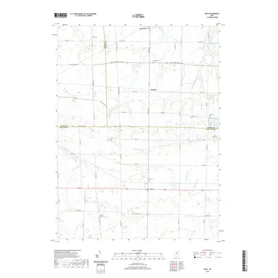
2019 Map of Nova
USGS Topo · Published 2019About this map
The village of Rochester and the settlement of Nova anchor this portrait of the rural borderlands where Huron, Lorain, and Ashland Counties meet. This agricultural landscape is defined by the branching tributaries of the Black River, including the W Br Black River and E Br Black River, which carve subtle drainages across the terrain. The area's heritage is deeply rooted in its early burial grounds, such as the German Lutheran Cem and Universalist Cem, suggesting the diverse denominational history of the nineteenth-century settlers. A unique cultural landmark, the Ukrainian Youth Camp Lake, appears in the northeast corner near Co Hwy 42, while small crossroads like Semples mark the intersections of a strictly rectangular road grid. This layout, including Townline Road 187, reflects the orderly division of the Firelands and surrounding Western Reserve tracts.
Find a feature on this map
38 named features on this map. Tap any name to fly to it.
Don’t see what you’re looking for? This feature index may not catch every label — zoom into the map to look around manually.
Map Details
Editions of this 2019 Nova Map
This is the sole edition of this map. No revisions or reprints were ever made.
Other maps of this area

1904 · Wellington
USGS Topo · 1:62,500

1906 · Wellington
USGS Topo · 1:62,500

1906 · West Salem
USGS Topo · 1:62,500

1908 · Ashland
USGS Topo · 1:62,500

1908 · West Salem
USGS Topo · 1:62,500

1908 · New London
USGS Topo · 1:62,500

1950 · Marion
USGS Topo · 1:250,000

1956 · Toledo
USGS Topo · 1:250,000
1960 · Wellington
USGS Topo · 1:24,000

1960 · New London
USGS Topo · 1:24,000