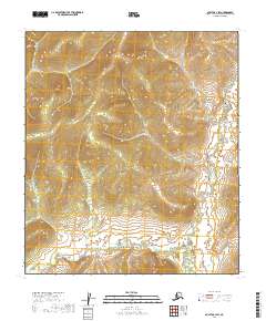
2019 Map of Nulato A-1 SW
USGS Topo · Published 2019About this map
The W Fork N Fork Innoko River winds across the southern reaches of this interior Alaskan landscape, following a sinuous path through a series of townships including t17s r12e and t17s r13e. This terrain is characterized by high, rounded ridges and deep drainage basins, where the lack of established roads or structures underscores the isolation of the Yukon-Koyukuk region. The map provides precise topographic detail of the hills rising north of the river, documenting the complex system of natural drainages that feed into the Innoko River watershed. It serves as a primary record of the undeveloped wilderness in the central part of the state, focusing on the intricate elevation changes between t16s r12e and the surrounding river valley.
Find a feature on this map
5 named features on this map. Tap any name to fly to it.
Don’t see what you’re looking for? This feature index may not catch every label — zoom into the map to look around manually.
Map Details
Editions of this 2019 Nulato A-1 SW Map
This is the sole edition of this map. No revisions or reprints were ever made.
Other maps of this area

1945 · Nulato
USGS Topo · 1:250,000

1951 · Ophir
USGS Topo · 1:250,000

1951 · Nulato
USGS Topo · 1:250,000

1952 · Nulato A-2
USGS Topo · 1:63,360
1952 · Nulato A-1
USGS Topo · 1:63,360

1952 · Nulato
USGS Topo · 1:250,000
1954 · Ophir D-1
USGS Topo · 1:63,360
1954 · Ophir D-2
USGS Topo · 1:63,360

1954 · Ophir
USGS Topo · 1:250,000

1964 · Nulato
USGS Topo · 1:250,000