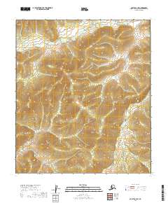
2019 Map of Nulato A-2 SW
USGS Topo · Published 2019About this map
Mud River meanders across this interior landscape within the Yukon-Koyukuk Census Area, defining the hydrological character of a terrain shaped by rhythmic drainage patterns. The map focuses on the confluence of low-lying waterways and upland ridges, dominated by the E Fork Yuki River as it cuts through the northern sections of the quadrangle. This 2019 survey provides a precise look at the township and range divisions, including t16s r10e and t17s r10e, which organize the remote territory. The lack of man-made infrastructure or named settlements emphasizes the untouched nature of this subarctic wilderness, where the land is primarily understood through its elevation contours and the paths of its primary rivers. Researchers can use this sheet to study the exact topography of the central Alaskan interior before potential shifts in the watershed or landscape.
Find a feature on this map
7 named features on this map. Tap any name to fly to it.
Don’t see what you’re looking for? This feature index may not catch every label — zoom into the map to look around manually.
Map Details
Editions of this 2019 Nulato A-2 SW Map
This is the sole edition of this map. No revisions or reprints were ever made.
Other maps of this area

1945 · Nulato
USGS Topo · 1:250,000

1951 · Ophir
USGS Topo · 1:250,000

1951 · Nulato
USGS Topo · 1:250,000

1952 · Nulato A-2
USGS Topo · 1:63,360

1952 · Nulato A-3
USGS Topo · 1:63,360

1952 · Nulato
USGS Topo · 1:250,000
1954 · Ophir D-3
USGS Topo · 1:63,360
1954 · Ophir D-2
USGS Topo · 1:63,360

1954 · Ophir
USGS Topo · 1:250,000

1964 · Nulato
USGS Topo · 1:250,000