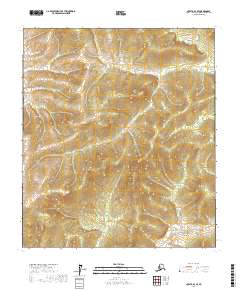
2017 Map of Nulato A-3 SE
USGS Topo · Published 2017About this map
The E Fork Yuki River meanders through the northern reaches of this interior Alaskan landscape, defining the topography of the Nulato A-3 SE region. This 2017 survey by the U.S. Geological Survey details an area dominated by the intricate drainage systems of the Yukon-Koyukuk Census Area, where the Mud River flows across the southern sections. The map serves as a primary record of the Public Land Survey System for this territory, clearly delineating the boundaries of t16s r8e, t16s r9e, t17s r8e, and t17s r9e. The absence of roads or established settlements emphasizes the remote nature of the terrain, where the primary landmarks are the seasonal watercourses and the underlying township and range grid.
Find a feature on this map
6 named features on this map. Tap any name to fly to it.
Don’t see what you’re looking for? This feature index may not catch every label — zoom into the map to look around manually.
Map Details
Editions of this 2017 Nulato A-3 SE Map
This is the sole edition of this map. No revisions or reprints were ever made.
Other maps of this area

1945 · Nulato
USGS Topo · 1:250,000

1951 · Ophir
USGS Topo · 1:250,000

1951 · Nulato
USGS Topo · 1:250,000

1952 · Nulato A-2
USGS Topo · 1:63,360

1952 · Nulato A-3
USGS Topo · 1:63,360

1952 · Nulato
USGS Topo · 1:250,000
1954 · Ophir D-3
USGS Topo · 1:63,360
1954 · Ophir D-2
USGS Topo · 1:63,360

1954 · Ophir
USGS Topo · 1:250,000

1964 · Nulato
USGS Topo · 1:250,000