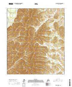
2017 Map of Nulato A-5 NW
USGS Topo · Published 2017About this map
Magitchlie Range dominates the southern landscape of this interior Alaska territory, where the terrain rises sharply from the surrounding river basins. The northwestern corner is defined by the winding course of the Khotol River, while the W Fork Little Mud River drains the central and eastern reaches of the quadrangle. This 2017 survey illustrates a land primarily shaped by its hydrology and elevation, showing the intricate drainage patterns that feed into the Yukon-Koyukuk river systems. The absence of roads or permanent settlements in this sector emphasizes its character as an undisturbed natural corridor where the high ridges of the Magitchlie Range provide a distinct topographical contrast to the lower-lying river valleys.
Find a feature on this map
9 named features on this map. Tap any name to fly to it.
Don’t see what you’re looking for? This feature index may not catch every label — zoom into the map to look around manually.
Map Details
Editions of this 2017 Nulato A-5 NW Map
This is the sole edition of this map. No revisions or reprints were ever made.
Other maps of this area

1945 · Nulato
USGS Topo · 1:250,000

1951 · Nulato
USGS Topo · 1:250,000

1952 · Nulato A-5
USGS Topo · 1:63,360

1952 · Nulato B-6
USGS Topo · 1:63,360

1952 · Nulato B-5
USGS Topo · 1:63,360

1952 · Nulato
USGS Topo · 1:250,000

1952 · Nulato A-6
USGS Topo · 1:63,360
1953 · Nulato B-5
USGS Topo · 1:63,360

1964 · Nulato
USGS Topo · 1:250,000
2017 · Nulato B-5 SW
USGS Topo · 1:25,000