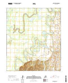
2017 Map of Nulato B-5 SW
USGS Topo · Published 2017About this map
The Khotol River dominates this portion of the Yukon-Koyukuk region, its serpentine channel winding through a landscape of oxbows and wetlands. This 2017 survey reveals the river's complex hydrologic patterns, where the Lakso Slough and Taku Cr feed into the main waterway. The southern reaches of the map are defined by the rising elevations of the Magitchlie Range, providing a sharp topographic contrast to the low-lying river valley to the north. Isolated water bodies like Fall Camp Lake dot the basin, illustrating the seasonal shifts and drainage characteristics of this interior Alaskan environment. This map is a primary resource for understanding the contemporary geography of these remote township coordinates, from the banks of the Khotol to the foothills of the Magitchlie heights.
Find a feature on this map
9 named features on this map. Tap any name to fly to it.
Don’t see what you’re looking for? This feature index may not catch every label — zoom into the map to look around manually.
Map Details
Editions of this 2017 Nulato B-5 SW Map
This is the sole edition of this map. No revisions or reprints were ever made.
Other maps of this area

1945 · Nulato
USGS Topo · 1:250,000

1951 · Nulato
USGS Topo · 1:250,000

1952 · Nulato A-5
USGS Topo · 1:63,360

1952 · Nulato B-6
USGS Topo · 1:63,360

1952 · Nulato B-5
USGS Topo · 1:63,360

1952 · Nulato
USGS Topo · 1:250,000

1952 · Nulato A-6
USGS Topo · 1:63,360
1953 · Nulato B-5
USGS Topo · 1:63,360

1964 · Nulato
USGS Topo · 1:250,000
2017 · Nulato A-5 NW
USGS Topo · 1:25,000