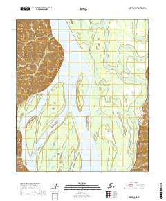
2017 Map of Nulato A-6 NE
USGS Topo · Published 2017About this map
The Yukon River dominates this interior landscape, carving a wide path through the Yukon-Koyukuk region as it flows past the distinctive bluff at Eightmile Point. The river’s shifting nature is evident in the presence of Little Eightmile Island and Big Eightmile Island, which divide the main channel. To the east, the Khotol River meanders through lower terrain, creating a complex network of braids and side channels characteristic of this subarctic floodplain. Steep elevations rise sharply to the west near Lears Point, providing a stark contrast to the low-lying river valleys where water and land constantly redefine one another. This survey illustrates the intricate relationship between the region's two major waterways and the high-ground landmarks that have likely served as navigational waypoints for generations.
Find a feature on this map
12 named features on this map. Tap any name to fly to it.
Don’t see what you’re looking for? This feature index may not catch every label — zoom into the map to look around manually.
Map Details
Editions of this 2017 Nulato A-6 NE Map
This is the sole edition of this map. No revisions or reprints were ever made.
Other maps of this area

1945 · Nulato
USGS Topo · 1:250,000

1951 · Nulato
USGS Topo · 1:250,000

1952 · Nulato A-5
USGS Topo · 1:63,360

1952 · Nulato B-6
USGS Topo · 1:63,360

1952 · Nulato B-5
USGS Topo · 1:63,360

1952 · Nulato
USGS Topo · 1:250,000

1952 · Nulato A-6
USGS Topo · 1:63,360
1953 · Nulato B-5
USGS Topo · 1:63,360

1964 · Nulato
USGS Topo · 1:250,000
2014 · Nulato A-6 SW
USGS Topo · 1:25,000