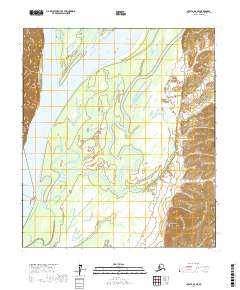
2017 Map of Nulato A-6 SE
USGS Topo · Published 2017About this map
The Yukon River dominates the western edge of this landscape in the Yukon-Koyukuk region, its massive channel carving through a complex system of islands and sloughs. This interior wilderness is defined by the winding course of the Khotol River, which snakes across the lowlands from the south before moving toward its confluence with the larger waterway. The map captures a highly dynamic environment of shifting sandbars and riparian wetlands, illustrating the natural state of these river systems in the early 21st century. High ground rises abruptly along the eastern and western margins, contrasting the flat, water-crossed interior basin. This survey provides a precise look at the township boundaries of t16s r1e, t16s r2e, and surrounding sections, marking the intersection of public land survey lines with the physical geography of the river valleys.
Find a feature on this map
6 named features on this map. Tap any name to fly to it.
Don’t see what you’re looking for? This feature index may not catch every label — zoom into the map to look around manually.
Map Details
Editions of this 2017 Nulato A-6 SE Map
This is the sole edition of this map. No revisions or reprints were ever made.
Other maps of this area

1945 · Nulato
USGS Topo · 1:250,000

1951 · Ophir
USGS Topo · 1:250,000

1951 · Nulato
USGS Topo · 1:250,000

1952 · Nulato A-5
USGS Topo · 1:63,360

1952 · Nulato
USGS Topo · 1:250,000

1952 · Nulato A-6
USGS Topo · 1:63,360
1954 · Ophir D-6
USGS Topo · 1:63,360
1954 · Ophir D-5
USGS Topo · 1:63,360

1954 · Ophir
USGS Topo · 1:250,000

1964 · Nulato
USGS Topo · 1:250,000