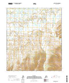
2017 Map of Nulato B-4 SW
USGS Topo · Published 2017About this map
North Cr and Eddy Cr define the drainage patterns of this Alaskan landscape within the Yukon-Koyukuk Census Area. The terrain transitions from a wetland-rich northern plain, dense with small ponds and glacial features, into more significant topographic relief in the southern sections. This 2017 study illustrates the remote character of the interior, where watercourses like North Cr carve through the land without the interference of modern infrastructure or permanent settlements. The lack of roads or established trails highlights the wilderness state of this region, which remains primarily defined by its natural hydrology and the established survey boundaries of Township 13 South and Township 14 South. For researchers, the map provides a precise record of the shoreline configurations and elevation contours at the headwaters of these minor tributaries.
Find a feature on this map
8 named features on this map. Tap any name to fly to it.
Don’t see what you’re looking for? This feature index may not catch every label — zoom into the map to look around manually.
Map Details
Editions of this 2017 Nulato B-4 SW Map
This is the sole edition of this map. No revisions or reprints were ever made.
Other maps of this area

1945 · Nulato
USGS Topo · 1:250,000

1951 · Nulato
USGS Topo · 1:250,000

1952 · Nulato A-5
USGS Topo · 1:63,360

1952 · Nulato A-4
USGS Topo · 1:63,360

1952 · Nulato B-5
USGS Topo · 1:63,360

1952 · Nulato B-4
USGS Topo · 1:63,360

1952 · Nulato
USGS Topo · 1:250,000
1953 · Nulato A-4
USGS Topo · 1:63,360
1953 · Nulato B-5
USGS Topo · 1:63,360

1964 · Nulato
USGS Topo · 1:250,000