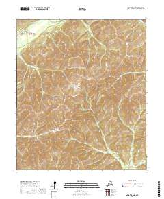
2017 Map of Nulato B-6 NW
USGS Topo · Published 2017About this map
South Fork Nulato River and the Ninemile River wind through this interior Alaska landscape, defining the hydrology of a region where the land itself remains largely undeveloped by modern industry. This 2017 survey reveals the intricate topography of the Yukon-Koyukuk Census Area, where a series of ridges and valleys are meticulously documented. The map is primarily organized by the Public Land Survey System, showing township and range divisions such as t11s r1w and t12s r1w. This area is characterized by its isolation, with no recorded roads or permanent settlements within the quadrangle boundaries, making it a pristine record of the drainage patterns and elevation profiles of the Nulato region.
Find a feature on this map
11 named features on this map. Tap any name to fly to it.
Don’t see what you’re looking for? This feature index may not catch every label — zoom into the map to look around manually.
Map Details
Editions of this 2017 Nulato B-6 NW Map
This is the sole edition of this map. No revisions or reprints were ever made.
Other maps of this area

1945 · Nulato
USGS Topo · 1:250,000

1948 · Norton Bay
USGS Topo · 1:250,000

1951 · Nulato
USGS Topo · 1:250,000

1951 · Norton Bay
USGS Topo · 1:250,000

1952 · Nulato B-6
USGS Topo · 1:63,360

1952 · Norton Bay B-1
USGS Topo · 1:63,360

1952 · Nulato C-6
USGS Topo · 1:63,360

1952 · Nulato
USGS Topo · 1:250,000
1952 · Norton Bay C-1
USGS Topo · 1:63,360
1953 · Nulato C-6
USGS Topo · 1:63,360