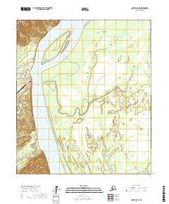
2017 Map of Nulato B-6 SE
USGS Topo · Published 2017About this map
Kaltag stands as a vital riverside hub along the western bank of the Yukon River, where the local infrastructure reflects the necessities of interior Alaskan life. This 2017 survey details the village grid, including A Street, C Street, and 5th Street, which connect the residential area to the essential Kaltag Airport. The surrounding landscape is defined by the braided channels of the Yukon and its tributaries, including the Kaltag River and Rodo River. Evidence of local industry and community services is seen in the naming of Gravel Pit Road and Cemetery Road. The map also captures the sprawling wetlands and meandering path of the Khotol River as it traverses the eastern flats, illustrating the precarious balance between the permanent settlement and the shifting northern hydrology.
Find a feature on this map
18 named features on this map. Tap any name to fly to it.
Don’t see what you’re looking for? This feature index may not catch every label — zoom into the map to look around manually.
Map Details
Editions of this 2017 Nulato B-6 SE Map
This is the sole edition of this map. No revisions or reprints were ever made.
Other maps of this area

1945 · Nulato
USGS Topo · 1:250,000

1951 · Nulato
USGS Topo · 1:250,000

1952 · Nulato A-5
USGS Topo · 1:63,360

1952 · Nulato B-6
USGS Topo · 1:63,360

1952 · Nulato B-5
USGS Topo · 1:63,360

1952 · Nulato
USGS Topo · 1:250,000

1952 · Nulato A-6
USGS Topo · 1:63,360
1953 · Nulato B-5
USGS Topo · 1:63,360

1964 · Nulato
USGS Topo · 1:250,000
2014 · Nulato B-6 SW
USGS Topo · 1:25,000