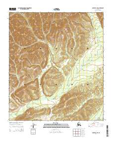
2014 Map of Nulato B-6 SW
USGS Topo · Published 2014About this map
Nulato Hills dominate the western portion of this topographic survey, illustrating the complex relief of the interior Alaska landscape near the Yukon River drainage. The map records the winding path of the Kaltag River as it meanders through the southern flats, showing the intricate hydrologic patterns typical of the region's subarctic river systems. On the eastern edge, the Rodo River emerges, highlighting the watershed divisions between these significant local water bodies. This 2014 edition, produced using data from the Alaska Dept. of Transportation and the National Hydrography Dataset, provides a precise record of the unpopulated terrain before any major changes in natural drainage or modern development altered the land's character.
Find a feature on this map
9 named features on this map. Tap any name to fly to it.
Don’t see what you’re looking for? This feature index may not catch every label — zoom into the map to look around manually.
Map Details
Editions of this 2014 Nulato B-6 SW Map
This is the sole edition of this map. No revisions or reprints were ever made.
Other maps of this area

1945 · Nulato
USGS Topo · 1:250,000

1948 · Norton Bay
USGS Topo · 1:250,000

1951 · Nulato
USGS Topo · 1:250,000

1951 · Norton Bay
USGS Topo · 1:250,000

1952 · Nulato B-6
USGS Topo · 1:63,360

1952 · Norton Bay B-1
USGS Topo · 1:63,360

1952 · Nulato
USGS Topo · 1:250,000

1952 · Nulato A-6
USGS Topo · 1:63,360
1954 · Norton Bay A-1
USGS Topo · 1:63,360

1955 · Norton Bay
USGS Topo · 1:250,000