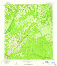
1954 Map of Norton Bay A-1
USGS Topo · Published 1959About this map
The Kaltag Mountains dominate this mid-century survey of the Alaskan interior, providing a detailed look at the traditional transit corridors through the Yukon-Koyukuk region. Central to the map is the Kaltag Portage, a vital overland link between the coastal drainage and the Yukon River system. This historic route is complemented by a Sled Trail that meanders across the high ground, illustrating the seasonal nature of transportation in the subarctic before modern infrastructure. The Unalakleet River and Rodo River carve through the deep valleys, while a single human outpost, Twentytwo Mile Cabin, serves as a landmark for travelers. This 1950s record documents a landscape defined by its waterways and primitive trails, such as Stink Creek, which remained essential for movement across this wilderness during the early Cold War era.
Find a feature on this map
7 named features on this map. Tap any name to fly to it.
Don’t see what you’re looking for? This feature index may not catch every label — zoom into the map to look around manually.
Map Details
Editions of this 1954 Norton Bay A-1 Map
2 editions found
Other maps of this area

1945 · Nulato
USGS Topo · 1:250,000

1948 · Norton Bay
USGS Topo · 1:250,000

1951 · Ophir
USGS Topo · 1:250,000

1951 · Nulato
USGS Topo · 1:250,000

1951 · Unalakleet
USGS Topo · 1:250,000

1951 · Norton Bay
USGS Topo · 1:250,000

1952 · Nulato B-6
USGS Topo · 1:63,360

1952 · Norton Bay B-1
USGS Topo · 1:63,360

1952 · Nulato
USGS Topo · 1:250,000

1952 · Nulato A-6
USGS Topo · 1:63,360