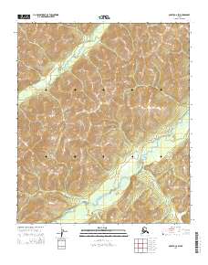
2014 Map of Nulato C-6 SW
USGS Topo · Published 2014About this map
Nulato Hills dominate the interior landscape of this 2014 topographic survey in the Yukon-Koyukuk region of Alaska. The terrain is characterized by a series of high ridges and narrow valleys that define the upper reaches of the S Fork Nulato River. The river winds across the southern portion of the sheet, fed by smaller tributaries like Kalasik Cr which drains the northwestern slopes. This map documents a vast, undeveloped territory within the Nulato quadrangle where the absence of roads or permanent structures underscores the isolation of the Alaskan interior. The cartography provides a precise record of the elevation contours and natural drainage patterns that have shaped this subarctic environment, offering a valuable reference for those studying the physical geography of the region.
Find a feature on this map
9 named features on this map. Tap any name to fly to it.
Don’t see what you’re looking for? This feature index may not catch every label — zoom into the map to look around manually.
Map Details
Editions of this 2014 Nulato C-6 SW Map
This is the sole edition of this map. No revisions or reprints were ever made.
Other maps of this area

1945 · Nulato
USGS Topo · 1:250,000

1948 · Norton Bay
USGS Topo · 1:250,000

1951 · Nulato
USGS Topo · 1:250,000

1951 · Norton Bay
USGS Topo · 1:250,000

1952 · Nulato B-6
USGS Topo · 1:63,360

1952 · Norton Bay B-1
USGS Topo · 1:63,360

1952 · Nulato C-6
USGS Topo · 1:63,360

1952 · Nulato
USGS Topo · 1:250,000
1952 · Norton Bay C-1
USGS Topo · 1:63,360
1953 · Nulato C-6
USGS Topo · 1:63,360