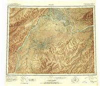
1945 Map of Nulato
USGS Topo · Published 1954About this map
The Yukon River and its major tributaries dictate the movement and settlement patterns of this Interior Alaska region during the mid-1940s. Established riverfront communities like Nulato and Koyukuk serve as critical hubs, while the map also notes the site of Tlatskokot (Aband), signaling the shifting nature of Indigenous and seasonal occupation. The convergence of the Koyukuk River and the Yukon is marked by Traders Island, a name hinting at the region's long history of commerce and river navigation.
Find a feature on this map
48 named features on this map. Tap any name to fly to it.
Don’t see what you’re looking for? This feature index may not catch every label — zoom into the map to look around manually.
Map Details
Editions of this 1945 Nulato Map
2 editions found
Other maps of this area

1945 · Nulato
USGS Topo · 1:250,000

1948 · Norton Bay
USGS Topo · 1:250,000

1950 · Medfra
USGS Topo · 1:250,000

1951 · Candle
USGS Topo · 1:250,000

1951 · Ophir
USGS Topo · 1:250,000

1951 · Nulato
USGS Topo · 1:250,000

1951 · Unalakleet
USGS Topo · 1:250,000

1951 · Ruby
USGS Topo · 1:250,000

1951 · Norton Bay
USGS Topo · 1:250,000

1951 · Kateel River
USGS Topo · 1:250,000