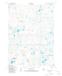
1952 Map of Nunivak Island A-3
USGS Topo · Published 1982About this map
Nunivak Island is defined here by its stark volcanic and arctic hydrology, captured in detail just after the mid-century. This portion of the Nunivak National Wildlife Refuge showcases a landscape of profound geological interest, anchored by the prominent Nanwaksjiak Crater and its adjacent Lava Bed in the southwest. The presence of these volcanic features amidst a complex network of tundra ponds and the winding Kaliksneethnoo River illustrates the unique intersection of igneous activity and the water-saturated soils of the Yukon Delta region. While the interior remains devoid of permanent settlements or roads, the map serves as a precise record of the island's natural drainage patterns and the established Base Line used for regional surveying. For the researcher, it provides a window into the untouched state of the Bering Sea's second-largest island before modern environmental shifts.
Find a feature on this map
7 named features on this map. Tap any name to fly to it.
Don’t see what you’re looking for? This feature index may not catch every label — zoom into the map to look around manually.
Map Details
Editions of this 1952 Nunivak Island A-3 Map
2 editions found
Other maps of this area

1951 · Cape Mendenhall
USGS Topo · 1:250,000

1951 · Nunivak Island
USGS Topo · 1:250,000

1952 · Cape Mendenhall D-4
USGS Topo · 1:63,360

1952 · Cape Mendenhall D-3
USGS Topo · 1:63,360

1952 · Nunivak Island A-4
USGS Topo · 1:63,360

1952 · Cape Mendenhall
USGS Topo · 1:250,000
1952 · Cape Mendenhall D-2
USGS Topo · 1:63,360

1952 · Nunivak Island A-3
USGS Topo · 1:63,360
1952 · Nunivak Island A-2
USGS Topo · 1:63,360
1952 · Nunivak Island B-3
USGS Topo · 1:63,360