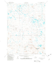
1952 Map of Nunivak Island A-4
USGS Topo · Published 1982About this map
Volcanic landforms and tundra wetlands dominate this portion of the Nunivak Island National Wildlife Refuge as surveyed in the early 1950s. The landscape is defined by dramatic geological features, including the prominent Ikathiwik Crater and Binalik Crater, alongside high points such as Mt Roberts and the Kimijooksuk Butte. These formations rise above a network of swamps and small lakes that drain into the Mekoryuk River.
Find a feature on this map
12 named features on this map. Tap any name to fly to it.
Don’t see what you’re looking for? This feature index may not catch every label — zoom into the map to look around manually.
Map Details
Editions of this 1952 Nunivak Island A-4 Map
2 editions found
Other maps of this area

1951 · Cape Mendenhall
USGS Topo · 1:250,000

1951 · Nunivak Island
USGS Topo · 1:250,000

1952 · Cape Mendenhall D-4
USGS Topo · 1:63,360

1952 · Cape Mendenhall D-3
USGS Topo · 1:63,360

1952 · Nunivak Island A-4
USGS Topo · 1:63,360

1952 · Cape Mendenhall
USGS Topo · 1:250,000

1952 · Nunivak Island A-5
USGS Topo · 1:63,360

1952 · Nunivak Island A-3
USGS Topo · 1:63,360
1952 · Nunivak Island B-5
USGS Topo · 1:63,360
1952 · Nunivak Island B-3
USGS Topo · 1:63,360