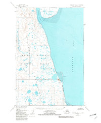
1950 Map of Nushagak Bay C-3
USGS Topo · Published 1982About this map
Igushik River carves through a landscape of marsh and mud flats as it empties into the western reaches of Nushagak Bay. This mid-century survey documents a coastal environment defined by tidal shifts and seasonal waterways, including the Tununig River and the prominent Nichols Spit. The map identifies the Igushik (Site) near the river mouth, indicating a location of historical habitation or seasonal use in a region that would later be encompassed by the Togiak National Wildlife Refuge.
Find a feature on this map
10 named features on this map. Tap any name to fly to it.
Don’t see what you’re looking for? This feature index may not catch every label — zoom into the map to look around manually.
Map Details
Editions of this 1950 Nushagak Bay C-3 Map
2 editions found
Other maps of this area

1945 · Nushagak Bay
USGS Topo · 1:250,000

1948 · Nushagak Bay D-4
USGS Topo · 1:63,360

1948 · Nushagak Bay D-3
USGS Topo · 1:63,360

1948 · Nushagak Bay C-4 And C-5
USGS Topo · 1:63,360

1949 · Nushagak Bay
USGS Topo · 1:250,000

1950 · Nushagak Bay B-4
USGS Topo · 1:63,360

1950 · Nushagak Bay C-3
USGS Topo · 1:63,360

1950 · Nushagak Bay C-4 And C-5
USGS Topo · 1:63,360
1950 · Nushagak Bay B-3
USGS Topo · 1:63,360

1951 · Nushagak Bay
USGS Topo · 1:250,000