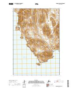
2019 Map of Nushagak Bay D-6 SW
USGS Topo · Published 2019About this map
Right Hand Point anchors the southern coastline of this landscape, reaching into the waters of Bristol Bay. This 2019 survey documents a coastal environment defined by a dense network of wetlands and small ponds, as recorded by the FWS National Wetlands Inventory. The interior is largely shaped by subtle elevation changes and glacial topography, with numerous unnamed water bodies scattered across the townships of t15s r64w, t15s r63w, t16s r64w, and t16s r63w. The absence of developed roads or named settlements underscores the isolated nature of this Alaskan shoreline, where the terrain is governed by the natural drainage patterns flowing toward the bay.
Find a feature on this map
6 named features on this map. Tap any name to fly to it.
Don’t see what you’re looking for? This feature index may not catch every label — zoom into the map to look around manually.
Map Details
Editions of this 2019 Nushagak Bay D-6 SW Map
This is the sole edition of this map. No revisions or reprints were ever made.
Other maps of this area

1945 · Nushagak Bay
USGS Topo · 1:250,000

1948 · Hagemeister Island C-1
USGS Topo · 1:63,360

1949 · Nushagak Bay
USGS Topo · 1:250,000

1950 · Nushagak Bay D-6
USGS Topo · 1:63,360

1950 · Hagemeister Island D-1
USGS Topo · 1:63,360

1951 · Hagemeister Island
USGS Topo · 1:250,000

1951 · Nushagak Bay
USGS Topo · 1:250,000

1952 · Hagemeister Island C-1
USGS Topo · 1:63,360

1952 · Hagemeister Island D-1
USGS Topo · 1:63,360

1957 · Hagemeister Island
USGS Topo · 1:250,000