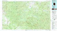
1981 Map of Nutrioso
USGS Topo · Published 1996About this map
Fort Apache Indian Reservation and the Apache National Forest dominate this high-altitude landscape in the early 1980s, where the Mogollon Rim marks a dramatic shift in the central Arizona topography. The map documents a network of mountain settlements and outposts, including Whiteriver, Fort Apache, and the isolated reaches of Hannagan Meadow and Sprucedale. Rising above the surrounding plateaus are massive landmarks like Mount Baldy and Escudilla Mountain, which anchor several dedicated wilderness areas.
Find a feature on this map
46 named features on this map. Tap any name to fly to it.
Don’t see what you’re looking for? This feature index may not catch every label — zoom into the map to look around manually.
Map Details
Editions of this 1981 Nutrioso Map
2 editions found
Other maps of this area

1886 · St Johns
USGS Topo · 1:250,000

1886 · Holbrook
USGS Topo · 1:250,000

1892 · St Johns
USGS Topo · 1:250,000

1893 · Holbrook
USGS Topo · 1:250,000

1910 · Mogollon
USGS Topo · 1:125,000

1912 · Mogollon
USGS Topo · 1:125,000

1913 · Morenci
USGS Topo · 1:125,000

1915 · Morenci
USGS Topo · 1:125,000

1915 · Reserve
USGS Topo · 1:125,000

1918 · Reserve
USGS Topo · 1:125,000