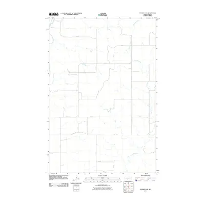
2011 Map of Nygren Dam
USGS Topo · Published 2011About this map
Nygren Dam serves as a focal point for this rural Morton County landscape, where the prairie topography is defined by the winding course of Chanta Peta Creek. The creek meanders extensively through the central and eastern portions of the quadrangle, illustrating the natural drainage patterns of the North Dakota plains before it eventually meets larger tributaries. In the northwestern corner, a segment of the Heart River cuts through the terrain, further emphasizing the importance of water management in this agricultural region. The map reveals a strictly organized section-line road network, including routes like County Rd 135, which connects the scattered farmsteads and rural properties. This survey provides a precise look at the 2011 land use and hydrology, documenting how simple earthen structures and natural waterways dictate the movement and settlement patterns across the open country.
Find a feature on this map
20 named features on this map. Tap any name to fly to it.
Don’t see what you’re looking for? This feature index may not catch every label — zoom into the map to look around manually.
Map Details
Editions of this 2011 Nygren Dam Map
This is the sole edition of this map. No revisions or reprints were ever made.
Other maps of this area

1954 · Bismarck
USGS Topo · 1:250,000

1958 · Bismarck
USGS Topo · 1:250,000

1980 · Green Ridge
USGS Topo · 1:24,000

1980 · Otter Creek East
USGS Topo · 1:24,000

1980 · Fallon NE
USGS Topo · 1:24,000

1980 · Burgess
USGS Topo · 1:24,000

1980 · Dogtooth Buttes
USGS Topo · 1:24,000
1980 · Fish Creek Lake
USGS Topo · 1:24,000

1980 · Nygren Dam
USGS Topo · 1:24,000
1980 · Elgin
USGS Topo · 1:100,000