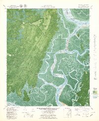
1979 Map of Oak Level
USGS Topo · Published 1979About this map
Kilkenny Creek and the meandering Ogeechee River define this coastal Georgia landscape, where the tides dictate the shape of the land and the livelihoods of its inhabitants. In the late 1970s, this area of Bryan County remained largely defined by its maritime connections, with settlements like Kilkenny and Fancy Hall situated near the intricate network of the Florida Passage Intracoastal Waterway. The map provides a detailed look at the transition from upland pine forests and trails near Oak Level to the expansive salt marshes and winding tidal guts like Little Tom Creek and Buckhead Creek. A Cem near Fancy Hall Road and landmarks like South End Field offer specific points of interest for genealogists tracing local families in this river-bound community. The presence of named islands such as Harveys Island and Queen Bess Island highlights the complexity of the coastal shoreline before modern development altered these traditional waterscapes.
Find a feature on this map
43 named features on this map. Tap any name to fly to it.
Don’t see what you’re looking for? This feature index may not catch every label — zoom into the map to look around manually.
Map Details
Editions of this 1979 Oak Level Map
3 editions found
Other maps of this area

1920 · Sapelo River
USGS Topo · 1:62,500

1920 · Limerick
USGS Topo · 1:62,500

1928 · St Catherines Island
USGS Topo · 1:62,500

1943 · St Catherines Island
USGS Topo · 1:62,500

1943 · Sapelo River
USGS Topo · 1:62,500

1944 · Limerick
USGS Topo · 1:62,500

1944 · Ossabaw Island
USGS Topo · 1:62,500

1945 · St. Catherine's Island
USGS Topo · 1:62,500

1945 · Ossabaw Island
USGS Topo · 1:62,500

1945 · Sapelo River
USGS Topo · 1:62,500