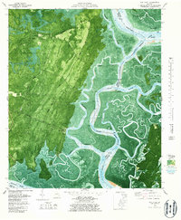
1979 Map of Oak Level
USGS Topo · Published 1987About this map
Redbird Creek and the tidal marshes of the Georgia coast dominate this orthophotomap, where the land and sea transition through a complex network of waterways. The settlement at Kilkenny sits at the junction of Kilkenny Road and Kilkenny Creek, illustrating the historical reliance on both terrestrial and maritime transport. Further south, the landscape is dotted with small communities like Fancy Hall and Retreat near the Medway River. The map highlights the strategic and commercial importance of the Florida Passage Intracoastal Waterway, which carves through the coastal islands including Harveys Island and Queen Bess Island. Inland, several named paths such as the Cottonham Trail and Oak Level Trail weave through the densely vegetated terrain toward the Oak Level community. These features collectively reflect a coastal economy built around river access and small-scale inland agriculture during the late 1970s.
Find a feature on this map
47 named features on this map. Tap any name to fly to it.
Don’t see what you’re looking for? This feature index may not catch every label — zoom into the map to look around manually.
Map Details
Editions of this 1979 Oak Level Map
3 editions found
Other maps of this area

1920 · Sapelo River
USGS Topo · 1:62,500

1920 · Limerick
USGS Topo · 1:62,500

1928 · St Catherines Island
USGS Topo · 1:62,500

1943 · St Catherines Island
USGS Topo · 1:62,500

1943 · Sapelo River
USGS Topo · 1:62,500

1944 · Limerick
USGS Topo · 1:62,500

1944 · Ossabaw Island
USGS Topo · 1:62,500

1945 · St. Catherine's Island
USGS Topo · 1:62,500

1945 · Ossabaw Island
USGS Topo · 1:62,500

1945 · Sapelo River
USGS Topo · 1:62,500