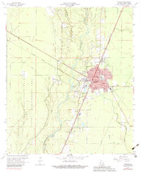
1968 Map of Oakdale
USGS Topo · Published 1983About this map
The timber and transit hub of Oakdale serves as the focal point of this 1960s landscape, situated where the Atchison Topeka and Santa Fe and Missouri Pacific railroads intersect. The town's infrastructure is well-established by this era, featuring the Oakdale Municipal Airport, Murray Airport, and specialized facilities like a Refinery and Drive-in Theater. To the west, the expansive West Bay State Wildlife Management Area dominates the terrain, drained by Curtis Creek and Baptiste Creek. This survey reveals a community deeply rooted in its local institutions, evidenced by numerous rural churches and cemeteries such as Oak Hill Ch and the Cryer Cem. The meandering Calcasieu River cuts through the center of the map, providing a natural contrast to the grid-like development of the town and its surrounding rail corridors.
Find a feature on this map
32 named features on this map. Tap any name to fly to it.
Don’t see what you’re looking for? This feature index may not catch every label — zoom into the map to look around manually.
Map Details
Editions of this 1968 Oakdale Map
3 editions found
Other maps of this area

1935 · Beaver
USGS Topo · 1:31,680

1935 · Pawnee
USGS Topo · 1:31,680

1935 · Oakdale
USGS Topo · 1:31,680

1942 · Oakdale
USGS Topo · 1:62,500

1947 · Foley
USGS Topo · 1:31,680

1947 · Steep Gully
USGS Topo · 1:31,680

1947 · Pine Chapel
USGS Topo · 1:31,680

1947 · Bond
USGS Topo · 1:31,680

1947 · Elizabeth
USGS Topo · 1:31,680

1948 · Elizabeth
USGS Topo · 1:24,000