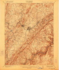
1900 Map of Oakland
USGS Topo · Published 1921About this map
The Backbone Mountain ridge dominates the terrain of Garrett County at the turn of the century, serving as a massive physical barrier between the Youghiogheny River headwaters and the North Branch Potomac River. The Baltimore and Ohio R. R. winds through this complex landscape, supporting established mountain communities like Oakland, Mountain Lake Park, and Deer Park. Along the southern border with West Virginia, Gormania and Bayard anchor the river crossings, while the historic Fort Pendleton stands near the Western Maryland R. R. line.
Find a feature on this map
76 named features on this map. Tap any name to fly to it.
Don’t see what you’re looking for? This feature index may not catch every label — zoom into the map to look around manually.
Map Details
Editions of this 1900 Oakland Map
5 editions found
Other maps of this area

1886 · St. George
USGS Topo · 1:125,000

1891 · St. George
USGS Topo · 1:125,000

1895 · Piedmont
USGS Topo · 1:125,000

1899 · Grantsville
USGS Topo · 1:62,500

1899 · Oakland
USGS Topo · 1:62,500

1900 · Accident
USGS Topo · 1:62,500

1900 · Oakland
USGS Topo · 1:62,500

1904 · Bruceton
USGS Topo · 1:62,500

1904 · Grantsville
USGS Topo · 1:62,500

1907 · Kingwood
USGS Topo · 1:62,500