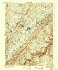
1900 Map of Oakland
USGS Topo · Published 1938About this map
Oakland serves as the focal point of this turn-of-the-century survey, situated at a vital junction of the B. & O. R. R. while the W. M. R. R. skirts the southern border. The landscape is defined by the steep relief of Backbone Mountain and Roman Nose Ridge, which channel the Youghiogheny River and its numerous tributaries like Muddy Run and Cherry Creek. The area shows a mature network of early Appalachian settlements, ranging from the resort-style layout of Mountain Lake Park and Loch Lynn to smaller railroad-dependent hamlets like Crellin, Hutton, and Gormania.
Find a feature on this map
86 named features on this map. Tap any name to fly to it.
Don’t see what you’re looking for? This feature index may not catch every label — zoom into the map to look around manually.
Map Details
Editions of this 1900 Oakland Map
5 editions found
Other maps of this area

1886 · St. George
USGS Topo · 1:125,000

1891 · St. George
USGS Topo · 1:125,000

1895 · Piedmont
USGS Topo · 1:125,000

1899 · Grantsville
USGS Topo · 1:62,500

1899 · Oakland
USGS Topo · 1:62,500

1900 · Accident
USGS Topo · 1:62,500

1900 · Oakland
USGS Topo · 1:62,500

1904 · Bruceton
USGS Topo · 1:62,500

1904 · Grantsville
USGS Topo · 1:62,500

1907 · Kingwood
USGS Topo · 1:62,500