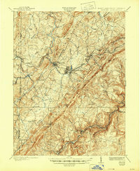
1900 Map of Oakland
USGS Topo · Published 1944About this map
Oakland serves as the central hub of this turn-of-the-century topographic study, which captures the high plateau and mountain ridges of western Garrett County. The Baltimore and Ohio RR dictates the development of the corridor, linking the resort communities of Mountain Lake Park and Loch Lynn with the rugged industrial and timber landscapes of Crellin and Hutton. Along the southern boundary, the North Branch Potomac River forms a jagged border with West Virginia, where twin settlements like Gorman and Gormania face one another across the water. The survey reveals a landscape of high summits including Backbone Mountain and Allegheny Heights, broken by significant natural features like Swallow Falls and Oak Shoals. Small family-named landmarks and rural centers such as Gnegy Church, Gortner, and Sunnyside provide a detailed look at the agricultural and social fabric of the Maryland mountains before modern highway development.
Find a feature on this map
74 named features on this map. Tap any name to fly to it.
Don’t see what you’re looking for? This feature index may not catch every label — zoom into the map to look around manually.
Map Details
Editions of this 1900 Oakland Map
5 editions found
Other maps of this area

1886 · St. George
USGS Topo · 1:125,000

1891 · St. George
USGS Topo · 1:125,000

1895 · Piedmont
USGS Topo · 1:125,000

1899 · Grantsville
USGS Topo · 1:62,500

1899 · Oakland
USGS Topo · 1:62,500

1900 · Accident
USGS Topo · 1:62,500

1900 · Oakland
USGS Topo · 1:62,500

1904 · Bruceton
USGS Topo · 1:62,500

1904 · Grantsville
USGS Topo · 1:62,500

1907 · Kingwood
USGS Topo · 1:62,500