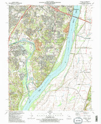
1991 Map of Oakville
USGS Topo · Published 1991About this map
The Mississippi River and Meramec River converge at the southern edge of this study, defining a landscape shaped by major watercourses and dense suburban development in south St. Louis County. This map documents the significant footprint of the Jefferson Barracks National Cemetery and the adjacent Jefferson Barracks Veterans Hospital along the river bluffs. In Oakville, a high concentration of schools and churches, such as Queen of All Saints Ch and Bernard Sch, indicates the area's late-twentieth-century residential maturation. The riverine environment is preserved in large tracts like Cliff Cave County Park and Bee Tree County Park, while the eastern bank reveals the low-lying agricultural expanse of the American Bottoms. Several smaller communities like Mattes and Flamm City appear alongside major transit corridors like Telegraph Road and the Burlington Northern railroad.
Find a feature on this map
77 named features on this map. Tap any name to fly to it.
Don’t see what you’re looking for? This feature index may not catch every label — zoom into the map to look around manually.
Map Details
Editions of this 1991 Oakville Map
2 editions found
Other maps of this area

1888 · St. Louis
USGS Topo · 1:62,500

1910 · Waterloo
USGS Topo · 1:62,500

1912 · Kimmswick
USGS Topo · 1:62,500

1913 · Waterloo
USGS Topo · 1:62,500

1916 · Kimmswick
USGS Topo · 1:62,500

1933 · Jefferson Barracks
USGS Topo · 1:24,000

1933 · Cahokia
USGS Topo · 1:24,000

1933 · Kirkwood
USGS Topo · 1:24,000

1934 · Cahokia
USGS Topo · 1:24,000
1940 · Cahokia
USGS Topo · 1:24,000