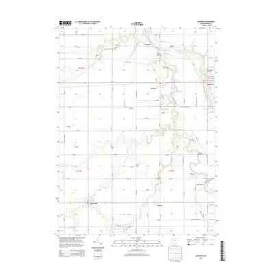
2013 Map of Oakwood
USGS Topo · Published 2013About this map
Oakwood and Grover Hill anchor this rural landscape in Paulding County, where the meandering paths of the Auglaize River and Little Auglaize River define the local topography. The map reveals a deeply established agricultural network, marked by namesake operations such as Germann Swine Farm, Sycamore Flats Farm, and Canal Farms. The small settlement of Melrose sits central to the quadrangle, while the site of Fort Brown near the confluence of the rivers speaks to the area's older frontier history. Genealogists will find a high density of burial sites including Auglaize Chapel Cem, Mellinger Cem, and Boutwell Cem, many located near the banks of creeks like Middle Creek and Prairie Cr. The presence of Canalport and Canal Farms reflects the legacy of early nineteenth-century water transport systems that once connected these Northwest Ohio communities to larger markets.
Find a feature on this map
128 named features on this map. Tap any name to fly to it.
Don’t see what you’re looking for? This feature index may not catch every label — zoom into the map to look around manually.
Map Details
Editions of this 2013 Oakwood Map
This is the sole edition of this map. No revisions or reprints were ever made.
Other maps of this area

1909 · Continental
USGS Topo · 1:62,500

1911 · Delphos
USGS Topo · 1:62,500

1914 · Van Wert
USGS Topo · 1:62,500

1914 · Paulding
USGS Topo · 1:62,500

1944 · Delphos
USGS Topo · 1:62,500

1944 · Van Wert
USGS Topo · 1:62,500

1944 · Paulding
USGS Topo · 1:62,500

1953 · Fort Wayne
USGS Topo · 1:250,000

1953 · Muncie
USGS Topo · 1:250,000

1956 · Muncie
USGS Topo · 1:250,000