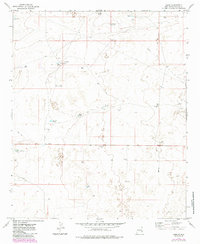
1973 Map of Oasis
USGS Topo · Published 1985About this map
Oasis serves as the focal point of this arid Chaves County landscape, where survival and commerce depend entirely on managed water sources. This 1970s survey illustrates a specialized ranching economy defined by numerous catchments and family-named landmarks, such as Hite Tanks, Westfall Tanks, and Crump Tanks. The infrastructure of the high plains is clearly marked, featuring a network of jeep trails and a significant pipeline cutting across the terrain. Scattered industrial activity is evident through various drill holes and an oil well, indicating the dual use of the land for both livestock and resource extraction. Significant ranching operations like Isler Ranch, Glenn Ranch, and Sand Ranch are positioned near their respective water tanks, showing the deliberate organization of the range in this part of New Mexico.
Find a feature on this map
26 named features on this map. Tap any name to fly to it.
Don’t see what you’re looking for? This feature index may not catch every label — zoom into the map to look around manually.
Map Details
Editions of this 1973 Oasis Map
2 editions found
Other maps of this area

1949 · Sardine Mountain
USGS Topo · 1:24,000

1949 · Malstrom Ranch
USGS Topo · 1:24,000

1954 · Brownfield
USGS Topo · 1:250,000

1955 · Roswell
USGS Topo · 1:250,000

1958 · Brownfield
USGS Topo · 1:250,000

1958 · Roswell
USGS Topo · 1:250,000

1962 · Roswell
USGS Topo · 1:250,000

1962 · Brownfield
USGS Topo · 1:250,000
1967 · Sardine Lake
USGS Topo · 1:24,000

1973 · Culp Ranch
USGS Topo · 1:24,000