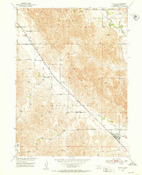
1951 Map of Oconto
USGS Topo · Published 1953About this map
Oconto and the settlement of Lodi serve as the primary hubs in this Custer County landscape, where the Union Pacific railroad tracks parallel the diagonal course of the Wood River. The map illustrates a rural Nebraska economy built on these transit corridors, connecting local cattle ranching and farming to larger markets. Educational and religious cornerstones of the community are well-documented, including the Lucky Star Sch and Lower Lodi Sch, alongside dedicated burial grounds such as St Mary Cem and Riverside Cem. The terrain is characterized by the flat expanse of Redfern Table in the southwest, contrasting with the more dissected hills near the South Loup River in the northeast. This 1951 survey reflects a mid-century period of established rural infrastructure just as the Missouri River Basin development program was shaping regional water and land use.
Find a feature on this map
19 named features on this map. Tap any name to fly to it.
Don’t see what you’re looking for? This feature index may not catch every label — zoom into the map to look around manually.
Map Details
Editions of this 1951 Oconto Map
3 editions found
Other maps of this area

1951 · Broken Bow SW
USGS Topo · 1:24,000

1951 · Callaway SE
USGS Topo · 1:24,000

1951 · Callaway
USGS Topo · 1:24,000

1951 · Oconto SW
USGS Topo · 1:24,000

1951 · Eddyville NW
USGS Topo · 1:24,000

1951 · Oconto SE
USGS Topo · 1:24,000

1951 · Eddyville SW
USGS Topo · 1:24,000

1951 · Oconto NW
USGS Topo · 1:24,000

1951 · Oconto
USGS Topo · 1:24,000

1955 · Broken Bow
USGS Topo · 1:250,000