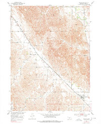
1951 Map of Oconto
USGS Topo · Published 1978About this map
Oconto stands as the primary hub in this central Nebraska landscape, positioned where the Union Pacific railroad corridor meets the winding valley of the Wood River. The settlement pattern reflects the mid-century agricultural and rail-dependent economy of Custer County, with small communities like Lodi and a network of rural schoolhouses distributed across the upland and valley floor. These institutions, including Lucky Star Sch and the Lower Lodi Sch, underscore a period when local education was decentralized and anchored in the immediate township.
Find a feature on this map
15 named features on this map. Tap any name to fly to it.
Don’t see what you’re looking for? This feature index may not catch every label — zoom into the map to look around manually.
Map Details
Editions of this 1951 Oconto Map
3 editions found
Other maps of this area

1951 · Broken Bow SW
USGS Topo · 1:24,000

1951 · Callaway SE
USGS Topo · 1:24,000

1951 · Callaway
USGS Topo · 1:24,000

1951 · Oconto SW
USGS Topo · 1:24,000

1951 · Eddyville NW
USGS Topo · 1:24,000

1951 · Oconto SE
USGS Topo · 1:24,000

1951 · Eddyville SW
USGS Topo · 1:24,000

1951 · Oconto NW
USGS Topo · 1:24,000

1951 · Oconto
USGS Topo · 1:24,000

1955 · Broken Bow
USGS Topo · 1:250,000