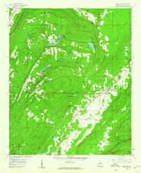
1958 Map of Odenville
USGS Topo · Published 1960About this map
The Cahaba Valley landscape of St. Clair County is defined by a dense network of mountain ridges and small agricultural settlements as they appeared in the late 1950s. Mining activity is evident throughout the terrain, from the strip mine near Springville Ch to the Watkins Cut along the Seaboard Railroad line. The rail infrastructure, including the Southern Railway and the Seaboard Air Line Railroad, anchors the economy of local communities like Odenville and Branchville.
Find a feature on this map
77 named features on this map. Tap any name to fly to it.
Don’t see what you’re looking for? This feature index may not catch every label — zoom into the map to look around manually.
Map Details
Editions of this 1958 Odenville Map
2 editions found
Other maps of this area

1889 · Springville
USGS Topo · 1:125,000

1889 · Birmingham
USGS Topo · 1:125,000

1892 · Birmingham
USGS Topo · 1:125,000

1892 · Springville
USGS Topo · 1:125,000

1895 · Birmingham
USGS Topo · 1:125,000

1905 · Leeds
USGS Topo · 1:62,500

1907 · Birmingham
USGS Topo · 1:125,000

1907 · Leeds
USGS Topo · 1:62,500

1953 · Birmingham
USGS Topo · 1:250,000

1956 · Birmingham
USGS Topo · 1:250,000